File:Yeojido.jpg
Jump to navigation
Jump to search

Size of this preview: 347 × 599 pixels. Other resolutions: 139 × 240 pixels | 278 × 480 pixels | 700 × 1,208 pixels.
Original file (700 × 1,208 pixels, file size: 394 KB, MIME type: image/jpeg)
Captions
Captions
Add a one-line explanation of what this file represents
Summary[edit]
| Description |
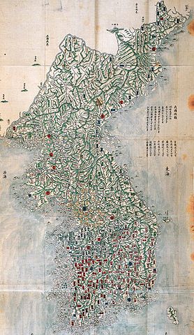
English: Yeojido also known as Aguk chongdo is a map of Korea in the late 18th century.
한국어: 아국총도(我國總圖)는 여지도(與地圖) 라고도 하며 18세기 말 정조시대에 제작된 전국지도로 화려한 색채가 돋보인다. 동해(東海)라는 표기가 바다 한가운데 있고, 독도가 우산도(于山島)라는 이름으로 울릉도 동쪽에 그려져 있다. 가로 82cm, 세로 152.5cm 서울대 규장각 소장 |
| Date | between 1789 and 1793 |
| Source | http://eastsea.nori.go.kr/data2.asp |
| Author |
King Jeongjo English: 정조시대에 means: during the reign of King Jeongjo, not Jeongjo fecit |
Licensing[edit]
|
This work is in the public domain in its country of origin and other countries and areas where the copyright term is the author's life plus 100 years or fewer. | |
| This file has been identified as being free of known restrictions under copyright law, including all related and neighboring rights. | |
File history
Click on a date/time to view the file as it appeared at that time.
| Date/Time | Thumbnail | Dimensions | User | Comment | |
|---|---|---|---|---|---|
| current | 08:21, 21 September 2008 | | 700 × 1,208 (394 KB) | Historiographer~commonswiki (talk | contribs) | {{Information |Description={{en|1=Yeojido also known as Aguk chongdo is a map of Korea in the late 18th century.}} {{ko|1=설명: 여지도(與地圖) 라고도 하며 18세기 말 정조시대에 제작된 전국지도로 화려한 색채가 돋보인다 |
You cannot overwrite this file.
File usage on Commons
The following page uses this file:
File usage on other wikis
The following other wikis use this file:
- Usage on ja.wikipedia.org
- Usage on ko.wikipedia.org
- Usage on th.wikipedia.org