File:XiongnuMap (with background).png
Jump to navigation
Jump to search

Size of this preview: 800 × 406 pixels. Other resolutions: 320 × 163 pixels | 640 × 325 pixels | 1,024 × 520 pixels | 1,280 × 650 pixels | 2,533 × 1,287 pixels.
Original file (2,533 × 1,287 pixels, file size: 7.24 MB, MIME type: image/png)
Captions
Captions
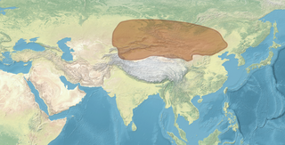
XiongnuMap (with background)
Summary[edit]
| Description |
English: XiongnuMap (with background). Matches the boundaries of this map, after correcting for slightly different projections:  |
| Date | |
| Source | |
| Author | Map created from DEMIS Mapserver, which are public domain. Koba-chan |


.png&action=edit§ion=1)
Licensing[edit]
.png&action=edit§ion=2)

|
Permission is granted to copy, distribute and/or modify this document under the terms of the GNU Free Documentation License, Version 1.2 or any later version published by the Free Software Foundation; with no Invariant Sections, no Front-Cover Texts, and no Back-Cover Texts. A copy of the license is included in the section entitled GNU Free Documentation License. |
| This file is licensed under the Creative Commons Attribution-Share Alike 3.0 Unported license. | ||
| ||
| This licensing tag was added to this file as part of the GFDL licensing update. |
File history
Click on a date/time to view the file as it appeared at that time.
| Date/Time | Thumbnail | Dimensions | User | Comment | |
|---|---|---|---|---|---|
| current | 19:12, 31 January 2023 | | 2,533 × 1,287 (7.24 MB) | पाटलिपुत्र (talk | contribs) | color |
| 19:09, 31 January 2023 |  | 2,533 × 1,287 (7.24 MB) | पाटलिपुत्र (talk | contribs) | tweak | |
| 19:05, 31 January 2023 |  | 2,508 × 1,274 (7.16 MB) | पाटलिपुत्र (talk | contribs) | colors | |
| 09:05, 25 December 2022 |  | 2,508 × 1,274 (2.15 MB) | पाटलिपुत्र (talk | contribs) | tweak | |
| 18:16, 12 December 2022 |  | 2,508 × 1,274 (2.14 MB) | पाटलिपुत्र (talk | contribs) | tweak | |
| 15:05, 12 December 2022 |  | 2,508 × 1,274 (2.15 MB) | पाटलिपुत्र (talk | contribs) | tweak | |
| 15:03, 12 December 2022 |  | 2,508 × 1,274 (2.15 MB) | पाटलिपुत्र (talk | contribs) | colors | |
| 21:18, 23 December 2021 |  | 2,508 × 1,274 (2.12 MB) | पाटलिपुत्र (talk | contribs) | Uploaded a work by Map created from [http://www2.demis.nl/mapserver/mapper.asp DEMIS Mapserver], which are public domain. Koba-chan from {{extracted from|File:Topographic90deg N0E0.png}} {{extracted from|File:Topographic90deg N0E90.png}} with UploadWizard |
You cannot overwrite this file.
File usage on Commons
The following page uses this file:
File usage on other wikis
The following other wikis use this file:
.png&oldid=729184615)