File:Wybory samorządowe 2010 Warszawa - rady dzielnic.PNG
Jump to navigation
Jump to search

Size of this preview: 781 × 599 pixels. Other resolutions: 313 × 240 pixels | 626 × 480 pixels | 1,001 × 768 pixels | 1,280 × 982 pixels | 2,560 × 1,964 pixels | 3,000 × 2,302 pixels.
Original file (3,000 × 2,302 pixels, file size: 316 KB, MIME type: image/png)
Captions
Captions
Add a one-line explanation of what this file represents
Summary[edit]
| Description |
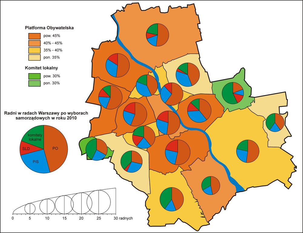
Polski: Mapa ukazująca poparcie dla zwycięskich komitetów wyborczych w wyborach do rad dzielnic Warszawy (kartogram) oraz liczbę miejsc w tychże radach, jaka przypadła poszczególnym komitetom (kartodiagram). Bazą dla wyrysowania granic dzielnic i miasta była ta mapa, a dane zostały zaczerpnięte ze strony www.wybory2010.pkw.gov.pl. |
| Date | |
| Source | Own work |
| Author | Viltharis |
Licensing[edit]
I, the copyright holder of this work, hereby publish it under the following licenses:

|
Permission is granted to copy, distribute and/or modify this document under the terms of the GNU Free Documentation License, Version 1.2 or any later version published by the Free Software Foundation; with no Invariant Sections, no Front-Cover Texts, and no Back-Cover Texts. A copy of the license is included in the section entitled GNU Free Documentation License. |
This file is licensed under the Creative Commons Attribution 3.0 Unported license.
- You are free:
- to share – to copy, distribute and transmit the work
- to remix – to adapt the work
- Under the following conditions:
- attribution – You must give appropriate credit, provide a link to the license, and indicate if changes were made. You may do so in any reasonable manner, but not in any way that suggests the licensor endorses you or your use.
You may select the license of your choice.
File history
Click on a date/time to view the file as it appeared at that time.
| Date/Time | Thumbnail | Dimensions | User | Comment | |
|---|---|---|---|---|---|
| current | 21:37, 27 November 2010 | | 3,000 × 2,302 (316 KB) | Viltharis (talk | contribs) | Zmniejszenie rozmiaru. |
| 21:31, 27 November 2010 |  | 6,379 × 4,896 (906 KB) | Viltharis (talk | contribs) | {{Information |Description={{pl|1=Mapa ukazująca poparcie dla zwycięskich komitetów wyborczych w wyborach do rad dzielnic Warszawy (kartogram) oraz liczbę miejsc w tychże radach, jaka przypadła poszczególnym komitetom (kartodiagram). Bazą dla wyry |
You cannot overwrite this file.
File usage on Commons
The following page uses this file:
File usage on other wikis
The following other wikis use this file:
- Usage on pl.wikipedia.org