File:Windkraftanlagen in Deutschland.png
Original file (1,421 × 1,871 pixels, file size: 2.54 MB, MIME type: image/png)
Captions
Captions
Summary[edit]
| Description |
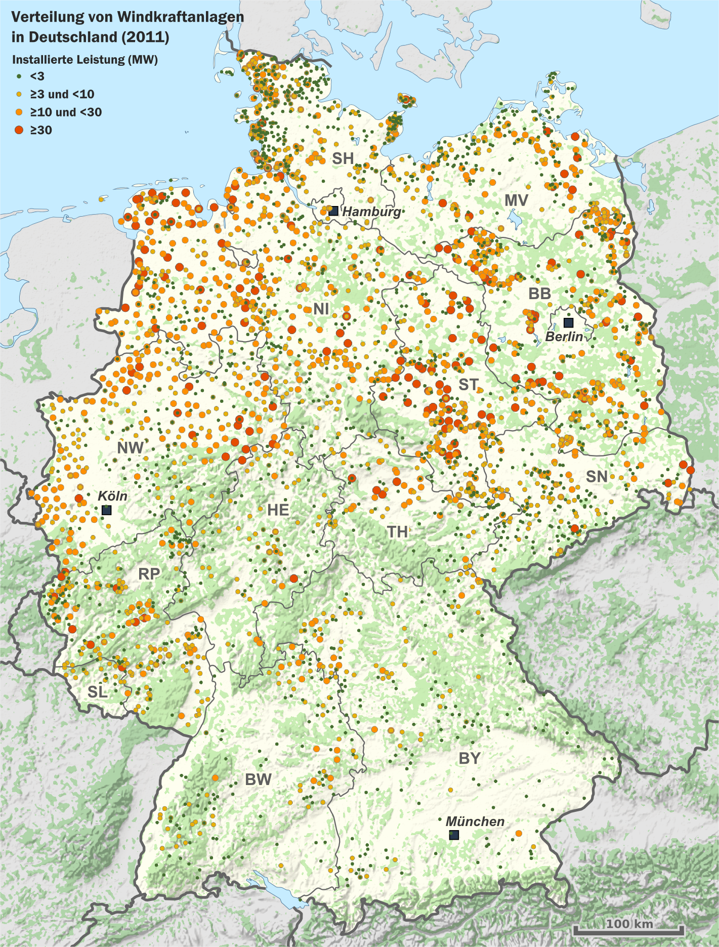
Deutsch: Karte der Verteilung von Windkraftanlagen (Windparks) in Deutschland 2011
Hinweise zur Datenverarbeitung: Die Anlagedaten wurden über ihre Orts-, Ortsteil und Postleitzahlen-Angaben geokodiert. Anlagen, die somit geografisch zusammenfallen, wurden in der Karte als ein Punkt dargestellt. Es handelt sich bei den Punkten also nicht unbedingt um Windparks mit einem betrieblichen Zusammenhang, sondern lediglich mit einem räumlichen Zusammenhang. Als Datengrundlage wurden die Meldungen der Anlagestammdaten der Übertragungsnetzbetreiber verwendet. Es wurden nur Anlagen in die Darstellung einbezogen, deren Inbetriebnahme vor dem 1.1.2012 lag. |
| Date | |
| Source |
Eigenes Werk (own work)
|
| Author | Alexrk2 |
| Permission (Reusing this file) |
|

|
This map has been made or improved in the German Kartenwerkstatt (Map Lab). You can propose maps to improve as well.
|
Licensing[edit]
- You are free:
- to share – to copy, distribute and transmit the work
- to remix – to adapt the work
- Under the following conditions:
- attribution – You must give appropriate credit, provide a link to the license, and indicate if changes were made. You may do so in any reasonable manner, but not in any way that suggests the licensor endorses you or your use.
- share alike – If you remix, transform, or build upon the material, you must distribute your contributions under the same or compatible license as the original.
File history
Click on a date/time to view the file as it appeared at that time.
| Date/Time | Thumbnail | Dimensions | User | Comment | |
|---|---|---|---|---|---|
| current | 12:34, 23 May 2016 | | 1,421 × 1,871 (2.54 MB) | RokerHRO (talk | contribs) | optipng → 16.93% decrease |
| 16:32, 6 January 2013 |  | 1,421 × 1,871 (3.05 MB) | Alexrk2 (talk | contribs) | Update 2011 | |
| 12:15, 24 September 2010 |  | 1,750 × 2,235 (692 KB) | Trockennasenaffe (talk | contribs) | optimized with OptiPNG | |
| 18:09, 1 February 2009 |  | 1,750 × 2,235 (1.1 MB) | Alexrk (talk | contribs) | Anlagen vervollständigt, Version ohne Zeitreihe | |
| 16:36, 11 December 2008 |  | 1,600 × 1,355 (728 KB) | Alexrk (talk | contribs) | Resize, Crop | |
| 16:30, 11 December 2008 |  | 1,626 × 1,474 (590 KB) | Alexrk (talk | contribs) | {{Information |Description={{de|1=Karte der Verteilung von Windkraftanlagen (Windparks) in Deutschland <br/><br/> Datenquellen: Anlagenstammdaten aus den Veröffentlichungen entspr. § 15 Abs. 2 EEG der Übertragungsnetzbetreiber Vattenfall, E.ON, EnBW un |
You cannot overwrite this file.
File usage on Commons
The following page uses this file:
File usage on other wikis
The following other wikis use this file:
- Usage on de.wikipedia.org
- Usage on en.wikipedia.org
- Usage on fr.wikipedia.org
- Usage on fy.wikipedia.org
- Usage on ja.wikipedia.org
- Usage on ru.wikipedia.org
- Usage on tr.wikipedia.org
- Usage on uz.wikipedia.org
- Usage on vi.wikipedia.org