File:Wien - Belvedere 21 (d).JPG
Jump to navigation
Jump to search

Size of this preview: 800 × 575 pixels. Other resolutions: 320 × 230 pixels | 640 × 460 pixels | 1,024 × 735 pixels | 1,280 × 919 pixels | 2,560 × 1,839 pixels | 5,650 × 4,058 pixels.
Original file (5,650 × 4,058 pixels, file size: 9.86 MB, MIME type: image/jpeg)
Captions
Captions
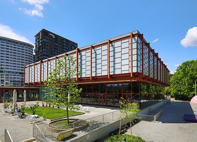
East view of the museum for contemporary art, film and music "Belvedere 21" in Vienna.
Summary[edit]
| Description |
Deutsch: Ostansicht des Museums „Belvedere 21“ (B21), ein Museum für zeitgenössische Kunst, Film und Musik, an der Adresse Arsenalstraße 1 im 3. Wiener Gemeindebezirk Landstraße.
Der Stahlskelettbau wurde nach Plänen des Architekten Karl Schwanzer 1958 als Österreichpavillon für die Weltausstellung 1958 in Brüssel errichtet. Anschließend wurde das Gebäude nach Wien in den Schweizergarten übertragen und diente ab 1962 als Museum des 20. Jahrhunderts (Spitzname: 20er Haus). 2002 erfolgte die Eingliederung in die Österreichische Galerie Belvedere und nach einer umfangreichen Renovierung im Jahr 2011 fand 2018 die Umbenennung in Belvedere 21 statt: [1]. English: East view of the museum for contemporary art, film and music "Belvedere 21" in Vienna. |
| Date | |
| Source | Own work |
| Author | C.Stadler/Bwag |
| Permission (Reusing this file) |
Deutsch: Hallo, du darfst mein Foto kostenlos nutzen, aber nenne mich bitte als Fotograf, beispielsweise „Foto: C.Stadler/Bwag“ oder © C.Stadler/Bwag; CC-BY-SA-4.0. Auf mehr Angaben bestehe ich nicht - im Gegensatz zu manch anderen, die die Vorgaben der unten angeführten Lizenzierung auf Punkt und Beistrich einfordern. English: Feel free to use my photos, but please mention me as the author like © C.Stadler/Bwag or © C.Stadler/Bwag; CC-BY-SA-4.0 (that's good enough) and if you want send me a message: bwag@gmx.net. |
| Other versions |
|
.JPG)
.JPG)

.JPG&action=edit§ion=1)
| Object location | | View this and other nearby images on: OpenStreetMap |
|---|
.JPG¶ms=048.185860_N_0016.383840_E_globe:Earth_class:object_type:object__&language=en)
| Camera location | | View this and other nearby images on: OpenStreetMap |
|---|
.JPG¶ms=048.185780_N_0016.384520_E_globe:Earth_type:camera_heading:285.00&language=en)
Licensing[edit]
.JPG&action=edit§ion=2)
I, the copyright holder of this work, hereby publish it under the following license:
This file is licensed under the Creative Commons Attribution-Share Alike 4.0 International license.
- You are free:
- to share – to copy, distribute and transmit the work
- to remix – to adapt the work
- Under the following conditions:
- attribution – You must give appropriate credit, provide a link to the license, and indicate if changes were made. You may do so in any reasonable manner, but not in any way that suggests the licensor endorses you or your use.
- share alike – If you remix, transform, or build upon the material, you must distribute your contributions under the same or compatible license as the original.
File history
Click on a date/time to view the file as it appeared at that time.
| Date/Time | Thumbnail | Dimensions | User | Comment | |
|---|---|---|---|---|---|
| current | 20:43, 3 May 2022 | | 5,650 × 4,058 (9.86 MB) | Bwag (talk | contribs) | == {{int:filedesc}} == {{Information |Description= {{de|1= Ostansicht des Museums „Belvedere 21“ (B21), ein Museum für zeitgenössische Kunst, Film und Musik, an der Adresse ''Arsenalstraße 1'' im 3. Wiener Gemeindebezirk Landstraße.<br/>Der Stahlskelettbau wurde nach Plänen des Architekten Karl Schwanzer 1958 als Österreichpavillon für die Weltausstellung 1958 in Brüssel errichtet. Anschließend wurde das Gebäude nach Wien in den Schweizergarten übertragen und diente ab 1962 als ''Museum des... |
You cannot overwrite this file.
File usage on Commons
The following 3 pages use this file:
File usage on other wikis
The following other wikis use this file:
- Usage on de.wikipedia.org
- Usage on en.wikipedia.org
- Usage on nl.wikipedia.org
- Usage on sv.wikipedia.org
.JPG&oldid=706208912)