File:White and Blue Nile-en.svg
Jump to navigation
Jump to search

Size of this PNG preview of this SVG file: 438 × 572 pixels. Other resolutions: 184 × 240 pixels | 367 × 480 pixels | 588 × 768 pixels | 784 × 1,024 pixels | 1,568 × 2,048 pixels.
Original file (SVG file, nominally 438 × 572 pixels, file size: 472 KB)
Captions
Captions
Add a one-line explanation of what this file represents
| Description | |
| Date | (UTC) |
| Source | |
| Author |
|
| Other versions |
|


I, the copyright holder of this work, hereby publish it under the following license:
This file is licensed under the Creative Commons Attribution-Share Alike 2.5 Generic, 2.0 Generic and 1.0 Generic license.
- You are free:
- to share – to copy, distribute and transmit the work
- to remix – to adapt the work
- Under the following conditions:
- attribution – You must give appropriate credit, provide a link to the license, and indicate if changes were made. You may do so in any reasonable manner, but not in any way that suggests the licensor endorses you or your use.
- share alike – If you remix, transform, or build upon the material, you must distribute your contributions under the same or compatible license as the original.
Original upload log
[edit]
This image is a derivative work of the following images:
- File:Nile-en.svg licensed with Cc-by-sa-2.5,2.0,1.0
- 2010-06-14T12:51:42Z Cryonic07 640x730 (756114 Bytes) {{Information |Description={{en|Map of the [[:en:Nile|Nile]] river.}} |Source=*[[:File:African_continent-en.svg|]] |Date=2010-06-14 12:46 (UTC) |Author=*[[:File:African_continent-en.svg|]]: *derivative work: [[User:Bobarino|B
Uploaded with derivativeFX
File history
Click on a date/time to view the file as it appeared at that time.
| Date/Time | Thumbnail | Dimensions | User | Comment | |
|---|---|---|---|---|---|
| current | 18:09, 6 August 2013 | | 438 × 572 (472 KB) | Hel-hama (talk | contribs) | northern section of map cropped |
| 17:53, 6 August 2013 |  | 438 × 802 (472 KB) | Hel-hama (talk | contribs) | Improved version of map to include lower Nile | |
| 04:00, 20 September 2011 |  | 365 × 480 (627 KB) | Alphathon (talk | contribs) | Added South Sudan using borders from File:South_Sudan-CIA_WFB_Map.png | |
| 11:11, 15 June 2010 |  | 365 × 480 (741 KB) | Cryonic07 (talk | contribs) | font size | |
| 09:28, 15 June 2010 |  | 365 × 480 (741 KB) | Cryonic07 (talk | contribs) | Italics. Lake Tana, Khartoum, Juba and Jinja marked | |
| 19:17, 14 June 2010 |  | 365 × 480 (736 KB) | Cryonic07 (talk | contribs) | Tanzania was not marked on the map | |
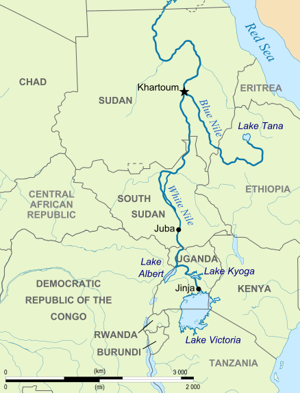
| 13:56, 14 June 2010 |  | 365 × 480 (734 KB) | Cryonic07 (talk | contribs) | {{Information |Description={{en|Map showing the White Nile and the Blue Nile}} |Source=*File:Nile-en.svg |Date=2010-06-14 13:32 (UTC) |Author=*File:Nile-en.svg: *[[:File:African_continent-en.svg|African_con |
You cannot overwrite this file.
File usage on Commons
The following 4 pages use this file:
File usage on other wikis
The following other wikis use this file:
- Usage on af.wikipedia.org
- Usage on ast.wikipedia.org
- Usage on ba.wikipedia.org
- Usage on br.wikipedia.org
- Usage on ca.wikipedia.org
- Usage on da.wikipedia.org
- Usage on de.wikipedia.org
- Usage on el.wikipedia.org
- Usage on en.wikipedia.org
- Usage on eo.wikipedia.org
- Usage on fa.wikipedia.org
- Usage on fo.wikipedia.org
- Usage on fr.wikipedia.org
- Usage on hu.wikipedia.org
- Usage on id.wikipedia.org
- Usage on ilo.wikipedia.org
- Usage on ja.wikipedia.org
- Usage on kn.wikipedia.org
- Usage on lv.wikipedia.org
- Usage on ml.wikipedia.org
- Usage on nl.wikipedia.org
- Usage on no.wikipedia.org
- Usage on pl.wikipedia.org
- Usage on ru.wikipedia.org
- Usage on sh.wikipedia.org
- Usage on sk.wikipedia.org
- Usage on sr.wikipedia.org
- Usage on sw.wikipedia.org
- Usage on ta.wikipedia.org
- Usage on uz.wikipedia.org
- Usage on yi.wikipedia.org
- Usage on zh.wikipedia.org