File:Wesersände Kurhannoversche Landesaufnahme 1773.png
Jump to navigation
Jump to search

Size of this preview: 406 × 600 pixels. Other resolutions: 162 × 240 pixels | 325 × 480 pixels | 520 × 768 pixels | 693 × 1,024 pixels | 1,336 × 1,973 pixels.
Original file (1,336 × 1,973 pixels, file size: 4.09 MB, MIME type: image/png)
Captions
Captions
Add a one-line explanation of what this file represents
Summary
[edit]
| Description |
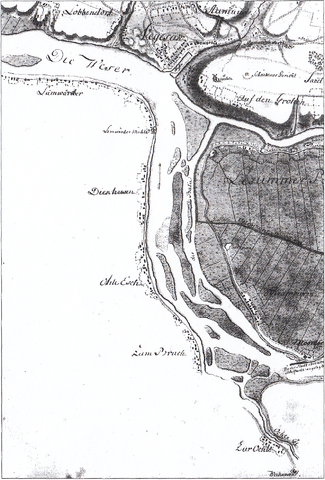
Deutsch: Die Wesersände zwischen den Mündungen von Lesum und Ochtum, Kurhannoversche Landesaufnahme 1773 |
| Date | |
| Source | scanned from "Ulrich Weidinger: Der Vegesacker Hafen - Ein Teil des frühneuzeitlichen Bremer Hafensystems. In: Historische Gesellschaft Bremen vom Staatsarchiv Bremen (Hrsg.): Bremisches Jahrbuch Band 82. Staatsarchiv, Bremen 2003, ISSN 0341-9622, S. 63" |
| Author | Created by officers of the Kurfürstentum Braunschweig-Lüneburg, Germany, 1773 |
Licensing
[edit]
|
This work is in the public domain in its country of origin and other countries and areas where the copyright term is the author's life plus 100 years or fewer. | |
| This file has been identified as being free of known restrictions under copyright law, including all related and neighboring rights. | |
File history
Click on a date/time to view the file as it appeared at that time.
| Date/Time | Thumbnail | Dimensions | User | Comment | |
|---|---|---|---|---|---|
| current | 19:50, 29 March 2011 | | 1,336 × 1,973 (4.09 MB) | XenonX3 (talk | contribs) | {{Information |Description ={{de|1=Die Wesersände zwischen den Mündungen von Lesum und Ochtum, de:Kurhannoversche Landesaufnahme 1773}} |Source =scanned from "Ulrich Weidinger: Der Vegesacker Hafen - Ein Teil des frühneuzeitlichen Brem |
You cannot overwrite this file.
File usage on Commons
The following page uses this file:
File usage on other wikis
The following other wikis use this file:
- Usage on de.wikipedia.org