File:Weltkarte tropen.png
From Wikimedia Commons, the free media repository
Jump to navigation
Jump to search

Size of this preview: 800 × 370 pixels. Other resolutions: 320 × 148 pixels | 640 × 296 pixels | 1,350 × 625 pixels.
Original file (1,350 × 625 pixels, file size: 200 KB, MIME type: image/png)
File information
Structured data
Captions
Captions
Add a one-line explanation of what this file represents
Summary[edit]
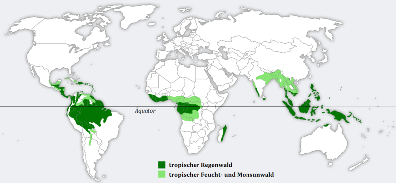
- Bildbeschreibung: die Verbreitung der Tropen, dargestellt auf einer Weltkarte
- Quelle: Vorlage für Weltkarte: http://en.wikipedia.org/wiki/Image:BlankMap-World.png ; die Verbreitung wurde dem Diercke Weltatlas 1992 entnommen und abgemalt.(Veränderungen möglich)
- Fotograf/Zeichner: c.lingg
- Datum: 03.04.2006
Licensing[edit]
This file is licensed under the Creative Commons Attribution-Share Alike 2.0 Germany license.
- You are free:
- to share – to copy, distribute and transmit the work
- to remix – to adapt the work
- Under the following conditions:
- attribution – You must give appropriate credit, provide a link to the license, and indicate if changes were made. You may do so in any reasonable manner, but not in any way that suggests the licensor endorses you or your use.
- share alike – If you remix, transform, or build upon the material, you must distribute your contributions under the same or compatible license as the original.

File history
Click on a date/time to view the file as it appeared at that time.
| Date/Time | Thumbnail | Dimensions | User | Comment | |
|---|---|---|---|---|---|
| current | 15:30, 21 July 2011 |  | 1,350 × 625 (200 KB) | W like wiki (talk | contribs) | i did an exchange between light green and dark grenn. for me it s a bit more logical, when in the center (Regenwald) there are intensive colors and on the edges (Feuchtwald) there are brighter colors. Ich war mal mutig und hab Hellgrün mit Dunkelgrün ve |
| 18:51, 17 February 2011 |  | 1,350 × 625 (246 KB) | Intforce (talk | contribs) | Deutsch: Äquator hinzugefügt, Schriftart-Änderung | |
| 16:25, 5 December 2008 |  | 1,350 × 625 (121 KB) | Jodo (talk | contribs) | typo, edit under given license | |
| 16:47, 27 March 2007 |  | 1,350 × 625 (77 KB) | Nils Simon (talk | contribs) | == Beschreibung, Quelle == * Bildbeschreibung: die Verbreitung der Tropen, dargestellt auf einer Weltkarte * Quelle: Vorlage für Weltkarte: http://en.wikipedia.org/wiki/Image:BlankMap-World.png ; die Verbreitung wurde dem Diercke Weltatlas 1992 entnomme |
You cannot overwrite this file.
File usage on Commons
The following page uses this file:
File usage on other wikis
The following other wikis use this file:
- Usage on de.wikipedia.org
- Usage on eo.wikipedia.org
- Usage on es.wikipedia.org
- Usage on eu.wikipedia.org
- Usage on frr.wikipedia.org
- Usage on hu.wikipedia.org
- Usage on io.wikipedia.org
- Usage on lt.wikipedia.org
- Usage on no.wikipedia.org
- Usage on ro.wikipedia.org
- Usage on sc.wikipedia.org
- Usage on sw.wikipedia.org
- Usage on www.wikidata.org