File:Wandel Sea map de.png
Jump to navigation
Jump to search
Size of this preview: 600 × 600 pixels. Other resolutions: 240 × 240 pixels | 480 × 480 pixels | 768 × 768 pixels | 1,024 × 1,024 pixels | 2,000 × 2,000 pixels.
Original file (2,000 × 2,000 pixels, file size: 198 KB, MIME type: image/png)
Captions
Captions
Add a one-line explanation of what this file represents
| Description |
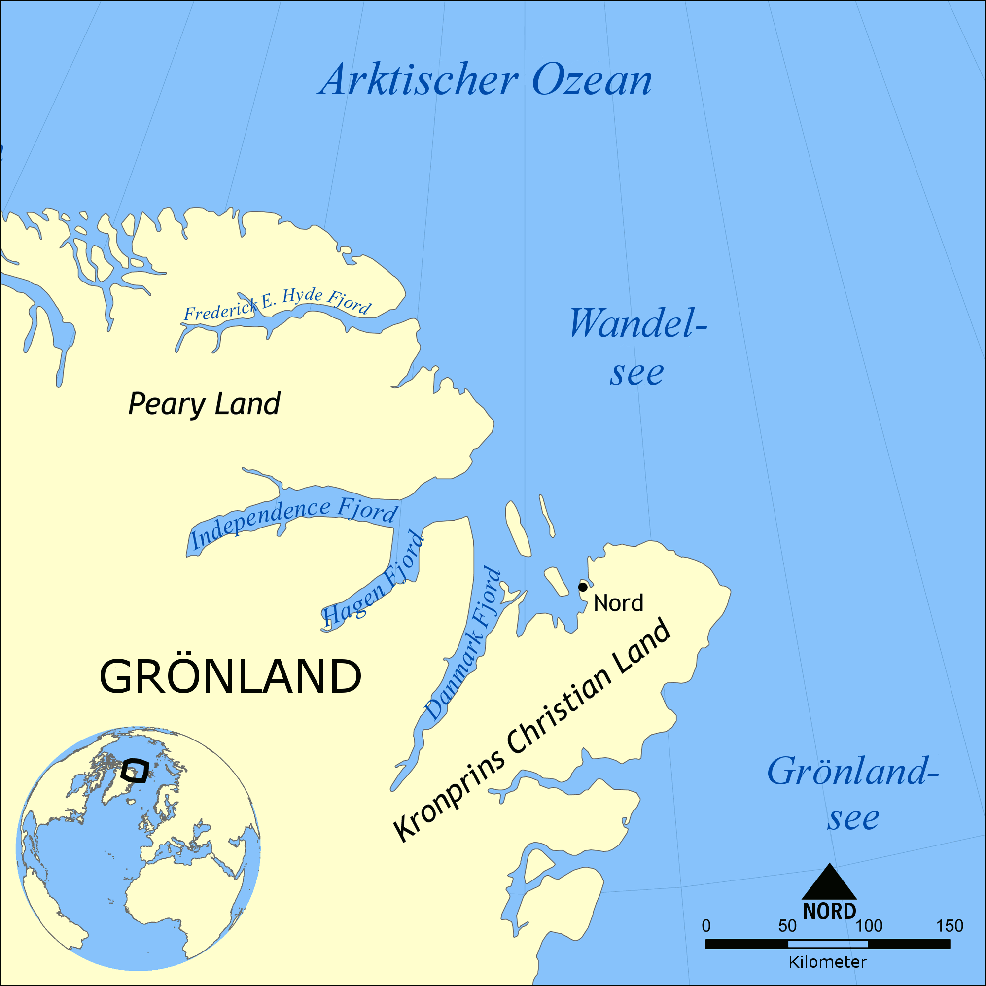
Deutsch: Diese Karte zeigt die Lage der Wandelsee nordwestlich Grönland und westlich Svalbard. Nahegelegene Gewässer sind Arktischer Ozean, Grönlandsee, Lincolnsee, Europäisches Nordmeer und de:Barentssee.
English: This map shows the location of the Wandel Sea northwest of Greenland and west of Svalbard. Nearby bodies of water include the Arctic Ocean, of which it is part, Category:Greenland Sea, Lincoln Sea, Norwegian Sea, and Barents Sea. |
| Date | (UTC) |
| Source | |
| Author |
|
| This is a retouched picture, which means that it has been digitally altered from its original version. Modifications: translated main labels to German. The original can be viewed here: Wandel Sea map.png:
|
I, the copyright holder of this work, hereby publish it under the following licenses:
This file is licensed under the Creative Commons Attribution-Share Alike 3.0 Unported license.
- You are free:
- to share – to copy, distribute and transmit the work
- to remix – to adapt the work
- Under the following conditions:
- attribution – You must give appropriate credit, provide a link to the license, and indicate if changes were made. You may do so in any reasonable manner, but not in any way that suggests the licensor endorses you or your use.
- share alike – If you remix, transform, or build upon the material, you must distribute your contributions under the same or compatible license as the original.

|
Permission is granted to copy, distribute and/or modify this document under the terms of the GNU Free Documentation License, Version 1.2 or any later version published by the Free Software Foundation; with no Invariant Sections, no Front-Cover Texts, and no Back-Cover Texts. A copy of the license is included in the section entitled GNU Free Documentation License. |
You may select the license of your choice.
Original upload log[edit]
This image is a derivative work of the following images:
- File:Wandel_Sea_map.png licensed with Cc-by-sa-3.0, GFDL
- 2009-05-04T18:18:04Z NormanEinstein 2000x2000 (217905 Bytes) Cropped map extent and added fjord names.
- 2009-01-27T16:59:00Z NormanEinstein 2000x1505 (378717 Bytes) {{Information |Description= |Source= |Date= |Author= |Permission= |other_versions= }}
- 2009-01-26T20:42:24Z NormanEinstein 1500x1129 (248154 Bytes) {{Information |Description={{en|1=This map shows the location of the Wandel Sea northwest of Greenland and west of Svalbard. Nearby bodies of water include the Arctic Ocean, of which it is part, Greenland Sea, Lincoln Sea, N
Uploaded with derivativeFX
File history
Click on a date/time to view the file as it appeared at that time.
| Date/Time | Thumbnail | Dimensions | User | Comment | |
|---|---|---|---|---|---|
| current | 14:55, 13 March 2010 | | 2,000 × 2,000 (198 KB) | Olaf Studt (talk | contribs) | {{Information |Description={{de|1=Diese Karte zeigt die Lage der de:Wandelsee nordwestlich Grönland und westlich Svalbard. Nahegelegene Gewässer sind de:Arktischer Ozean, de:Grönlandsee, de:Lincolnsee, [[:de:Europäisches Nordme |
You cannot overwrite this file.
File usage on Commons
There are no pages that use this file.
File usage on other wikis
The following other wikis use this file:
- Usage on de.wikipedia.org