File:WW2 Holocaust Europe map-it.svg
Jump to navigation
Jump to search

Size of this PNG preview of this SVG file: 721 × 600 pixels. Other resolutions: 289 × 240 pixels | 577 × 480 pixels | 923 × 768 pixels | 1,231 × 1,024 pixels | 2,461 × 2,048 pixels | 1,310 × 1,090 pixels.
Original file (SVG file, nominally 1,310 × 1,090 pixels, file size: 550 KB)
Captions
Captions
Add a one-line explanation of what this file represents
Summary
[edit]| Description |
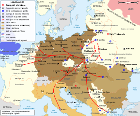
Italiano: Mappa dell'Olocausto in Europa durante la Seconda Guerra Mondiale (1939-1945) |
| Date | |
| Source | |
| Author |
|
| Permission (Reusing this file) |
FAL. |
| Other versions |
[]
|


.png)


.png)


Licensing
[edit]
| Copyleft: This work of art is free; you can redistribute it and/or modify it according to terms of the Free Art License. You will find a specimen of this license on the Copyleft Attitude site as well as on other sites. |
Original upload log
[edit]
The original description page was here. All following user names refer to it.wikipedia.
| Date/Time | Dimensions | User | Comment |
|---|---|---|---|
| 2014-01-30 21:21 | 1310×1090× (563187 bytes) | Mess | ulteriori aggiustamenti |
| 2014-01-30 10:26 | 1310×1090× (548988 bytes) | Mess | distinzione corretta tra campi di concentramento e campi di raccolta + correzioni minori |
| 2014-01-29 17:53 | 1310×1090× (497523 bytes) | Mess | {{Informazioni file |Descrizione = Mappa dell'Olocausto in Europa durante la Seconda Guerra Mondiale (1939-1945) |Fonte = *[[:File:WW2-Holocaust-Europe.png|WW2-Holocaust-Europe.png]] |Data = 29 gennaio 2014 |Autore = *[[:File:WW2-Holocaust-Europe.png|W... |
File history
Click on a date/time to view the file as it appeared at that time.
| Date/Time | Thumbnail | Dimensions | User | Comment | |
|---|---|---|---|---|---|
| current | 20:51, 2 February 2019 | | 1,310 × 1,090 (550 KB) | Mess (talk | contribs) | Transferred from it.wikipedia via #commonshelper |
You cannot overwrite this file.
File usage on Commons
The following 25 pages use this file:
- User:Magog the Ogre/Maps of conflicts/2019 February
- File:WW2-Holocaust-Europe-2007Borders.png
- File:WW2-Holocaust-Europe-2007Borders DE.png
- File:WW2-Holocaust-Europe-he.png
- File:WW2-Holocaust-Europe.png
- File:WW2-Holocaust-Europe DE.png
- File:WW2-Holocaust-Europe DE 2.png
- File:WW2-Holocaust-Europe blank.png
- File:WW2-Holocaust-Poland-ru.png
- File:WW2-Holocaust-Poland-ukr.jpg
- File:WW2-Holocaust-Poland.PNG
- File:WW2-Holocaust-Poland (Français).png
- File:WW2-Holocaust-Poland (without comment).png
- File:WW2-Holocaust-Poland big legend.PNG
- File:WW2-Zagłada-Żydów-Polska.png
- File:WW2 Holocaust Europe N-E map-fr.svg
- File:WW2 Holocaust Europe map-blank.svg
- File:WW2 Holocaust Europe map-es.svg
- File:WW2 Holocaust Europe map-fr.svg
- File:WW2 Holocaust Europe map-it.svg
- File:WW2 Holocaust Europe map-pt.svg
- File:WW2 Holocaust Europe map-zh-hans.svg
- File:WW2 Holocaust Poland map-fr.svg
- File:Холокост в Европе.png
- Template:Other versions/WW2 Holocaust Europe map
File usage on other wikis
The following other wikis use this file:
- Usage on it.wikipedia.org
- Usage on it.wikibooks.org