File:WANA according to ICARDA 2011.svg
Jump to navigation
Jump to search

Size of this PNG preview of this SVG file: 550 × 550 pixels. Other resolutions: 240 × 240 pixels | 480 × 480 pixels | 768 × 768 pixels | 1,024 × 1,024 pixels | 2,048 × 2,048 pixels.
Original file (SVG file, nominally 550 × 550 pixels, file size: 1.51 MB)
Captions
Captions
Add a one-line explanation of what this file represents
Summary[edit]
| Description |
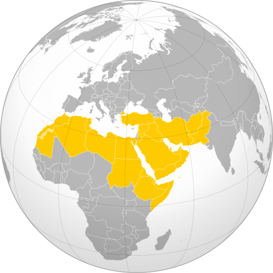
English: The WANA region (West Asia/North Africa) according to a 2011 study of ICARDA (International Center for Agricultural Research in the Dry Areas). |
| Date | |
| Source |
Own work, derived from File:Greater Middle East (orthographic projection).svg. Source used in creating this map:
|
| Author | Nederlandse Leeuw |
| Other versions |
|


.png)
.svg)
Licensing[edit]
I, the copyright holder of this work, hereby publish it under the following license:
This file is licensed under the Creative Commons Attribution-Share Alike 4.0 International license.
- You are free:
- to share – to copy, distribute and transmit the work
- to remix – to adapt the work
- Under the following conditions:
- attribution – You must give appropriate credit, provide a link to the license, and indicate if changes were made. You may do so in any reasonable manner, but not in any way that suggests the licensor endorses you or your use.
- share alike – If you remix, transform, or build upon the material, you must distribute your contributions under the same or compatible license as the original.
File history
Click on a date/time to view the file as it appeared at that time.
| Date/Time | Thumbnail | Dimensions | User | Comment | |
|---|---|---|---|---|---|
| current | 13:51, 18 January 2021 | | 550 × 550 (1.51 MB) | Nederlandse Leeuw (talk | contribs) | Uploaded own work with UploadWizard |
You cannot overwrite this file.
File usage on Commons
The following 5 pages use this file:
File usage on other wikis
The following other wikis use this file:
- Usage on en.wikipedia.org