File:Vulnerable shores ESA361223.jpg
Jump to navigation
Jump to search

Size of this preview: 800 × 424 pixels. Other resolutions: 320 × 170 pixels | 640 × 340 pixels | 1,097 × 582 pixels.
Original file (1,097 × 582 pixels, file size: 142 KB, MIME type: image/jpeg)
Captions
Captions
Add a one-line explanation of what this file represents
Summary
[edit]
| Description |
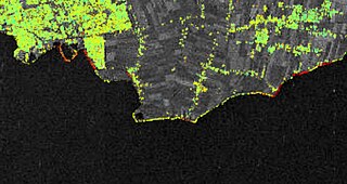
English: Sentinel-1A has been used to measure subsidence along the shores of the Markermeer in the Netherlands. This map, which is a zoom-in of alarger map, shows the area around the city of Hoorn. Areas where the ground is moving are shown in red, while green areas show where the ground is stable.
Read full story:Mapping that sinking feeling |
| Date | |
| Source | http://www.esa.int/spaceinimages/Images/2016/06/Vulnerable_shores |
| Author | European Space Agency |
| Permission (Reusing this file) |
contains modified Copernicus Sentinel data (2014–16), processed by ESA SEOM INSARAP study/PPO.labs /Norut/NGU,CC BY-SA 3.0 IGO |
| Title | Vulnerable shores |
| Mission | Sentinel-1 |
| Activity | Observing the Earth |
Licensing
[edit]
This file is licensed under the Creative Commons Attribution-ShareAlike 3.0 IGO license.
- You are free:
- to share – to copy, distribute and transmit the work
- to remix – to adapt the work
- Under the following conditions:
- attribution – You must give appropriate credit, provide a link to the license, and indicate if changes were made. You may do so in any reasonable manner, but not in any way that suggests the licensor endorses you or your use.
- share alike – If you remix, transform, or build upon the material, you must distribute your contributions under the same or compatible license as the original.
File history
Click on a date/time to view the file as it appeared at that time.
| Date/Time | Thumbnail | Dimensions | User | Comment | |
|---|---|---|---|---|---|
| current | 15:53, 6 May 2017 | | 1,097 × 582 (142 KB) | Fæ (talk | contribs) | == {{int:filedesc}} == {{information | description = {{en|1=Sentinel-1A has been used to measure subsidence along the shores of the Markermeer in the Netherlands. This map, which is a zoom-in of alarger map, shows the area around the city of Hoorn. Are... |
You cannot overwrite this file.
File usage on Commons
The following page uses this file: