File:Vollenhove Kaart Frederik de Wit.jpg

Original file (1,024 × 767 pixels, file size: 133 KB, MIME type: image/jpeg)
Captions
Captions
Summary[edit]
| Author |
|
|||||||||||||||||||||||||
| Title |
Français : Le theatre des plans de toutes les villes qui sont situéez dans les XVII Provinces du Pays Bas parfaictement déseignéez
Latina: Theatrum ichnographicum omnium urbium et præcipuorum oppidorum Belgicarum XVII Provinciarum peraccurate delineatarum.
Nederlands: Perfecte aftekeningen der steden van de XVII Nederlandsche Provincien in platte gronden |
|||||||||||||||||||||||||
| Object type | Atlas | |||||||||||||||||||||||||
| Description |
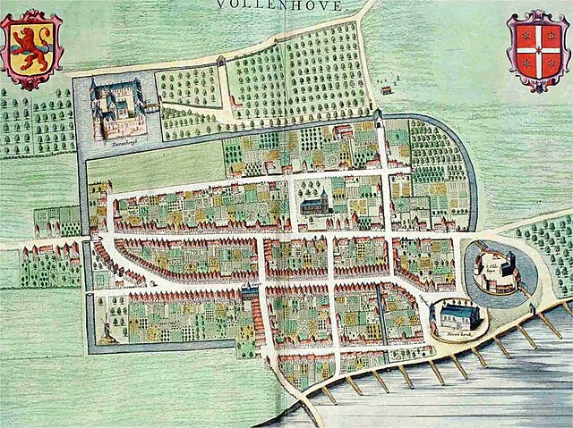
English: Plate 'pl061'(Vollenhoven) from the Stedenboek (citybook) by Frederick de Wit.
Nederlands: Plaat 'pl061'(Vollenhoven) uit het Stedenboek van Frederick de Wit, see 'Other versions'. Let op: het zuiden is boven! Linksboven staat het wapen van Overijssel, rechtsboven het wapen van Vollenhove. Op de oorspronkelijke kaart staat linksonder een schaalstok in Rhynlandse Roeden, maar die is op deze weergave afgesneden. Dat geldt ook voor de tekst rechtsonder: De Zuyder Zee. Voorgaande informatie is afkomstig van de Koninklijke Bibliotheek. Hieronder volgt informatie uit een mogelijk minder betrouwbare bron. Voor een ruimere weergave, zie:
|
|||||||||||||||||||||||||
| Date | circa 1698 | |||||||||||||||||||||||||
| Medium | Print, coloured by hand | |||||||||||||||||||||||||
| Collection |
|
|||||||||||||||||||||||||
| Place of creation | Amsterdam, the Netherlands | |||||||||||||||||||||||||
| Source/Photographer | http://www.henkvanheerde.nl/vollenhove/ | |||||||||||||||||||||||||
| Permission (Reusing this file) |
PD-OLD | |||||||||||||||||||||||||
| Other versions |
Atlas de Wit 1698-pl061-Vollenhoven-KB PPN 145205088.jpg:  |
|||||||||||||||||||||||||

Licensing[edit]
|
This work is in the public domain in its country of origin and other countries and areas where the copyright term is the author's life plus 70 years or fewer.
| |
| This file has been identified as being free of known restrictions under copyright law, including all related and neighboring rights. | |
File history
Click on a date/time to view the file as it appeared at that time.
| Date/Time | Thumbnail | Dimensions | User | Comment | |
|---|---|---|---|---|---|
| current | 06:57, 16 December 2007 | | 1,024 × 767 (133 KB) | WikiFB3 (talk | contribs) | {{Information |Description=kaart van Vollenhove, nummer 99 uit het boek Novum ac magnum Theatrum urbium Belgicae Foederatae (tussen pagina 185 en186), van uitgever/drukker Johannes Blaeu uit 1649. Het is een profielkaart, gemaakt door een onbekende tekena |
You cannot overwrite this file.
File usage on Commons
The following 2 pages use this file:
File usage on other wikis
The following other wikis use this file:
- Usage on en.wikipedia.org
- Usage on fa.wikipedia.org
- Usage on it.wikipedia.org
- Usage on nl.wikipedia.org
- Usage on uk.wikipedia.org
- Usage on zh.wikipedia.org