File:Volga River Delta (MODIS 2019-08-21).jpg

Original file (3,689 × 2,908 pixels, file size: 850 KB, MIME type: image/jpeg)
Captions
Captions
Summary[edit]
.jpg&action=edit§ion=1)
| Description |
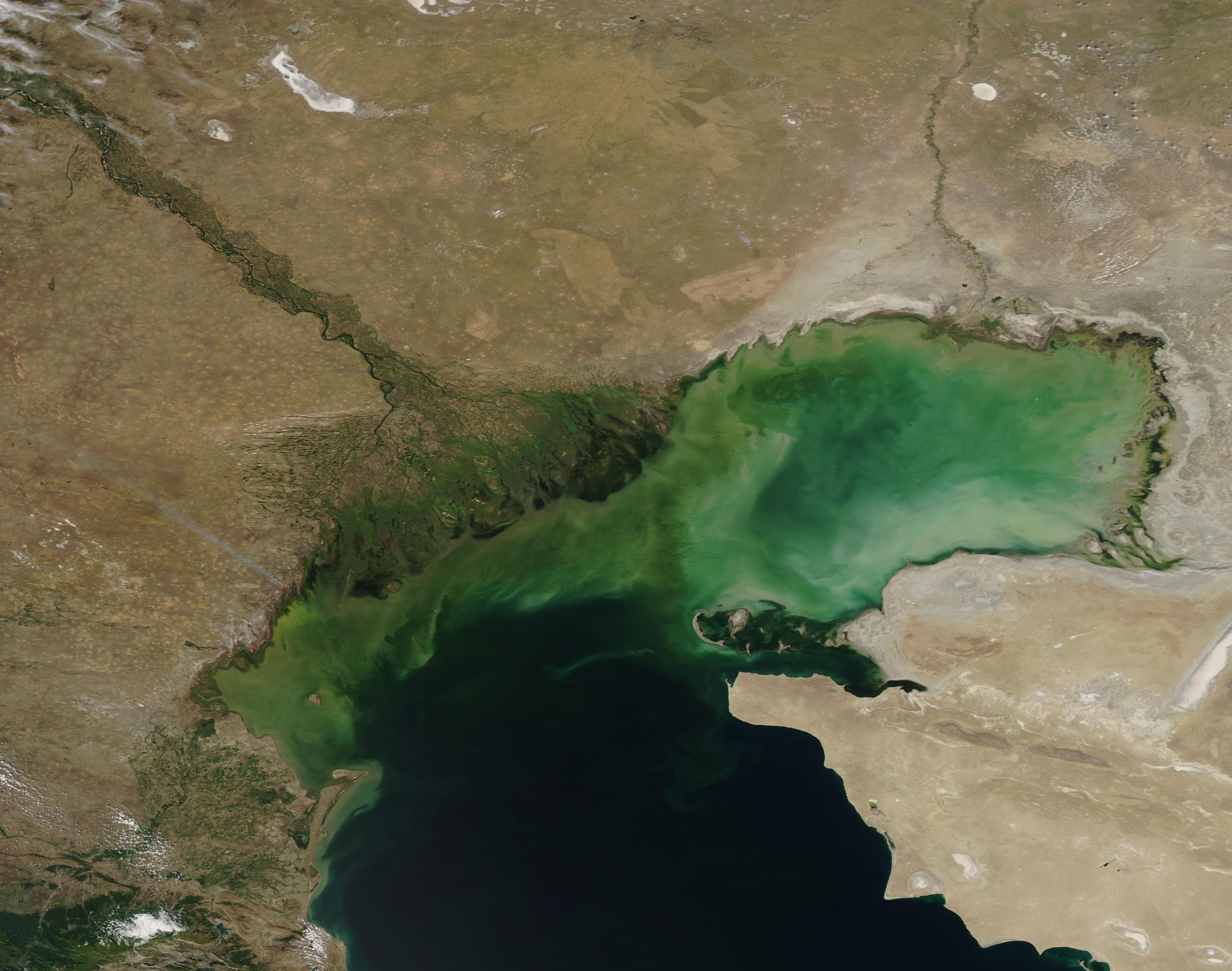
English: The Volga River Delta, the largest inland river delta in Europe, spreads about 100 miles (160 km) across southern Russia and, in the east, crosses the border with Kazakhstan. The mighty Volga River rises northwest of Moscow and flows about 2,175 miles (3,500 km) before emptying into the northern part of the Caspian Sea near the city of Astrakhan.
Over the past century, the Volga Delta has grown from 3,222 square kilometers (1,244 square miles) in 1880 to 27,224 square kilometers (10,511 square miles) in 2018. This significant growth is due both to sea level changes in the Caspian and the broad, gentle slope of the delta. When water from the river enters the delta, it gets split up into hundreds of waterways, creating one of the world’s most complicated hydrographic networks. The delta is composed of three distinct zones. The first and most prominent includes the higher areas of the delta, which are dominated by very large linear mounds and basins. The second has very low relief and is the site of active and abandoned water channels which approach the coast of the Caspian Sea. The third zone a large, broad submerged platform that extends 20 to 40 miles (30-60 km) offshore. Large volumes of sediment and nutrient-laden water pour from the Volga River, first through the muddy channels and then across the shallow platform, where they stir additional sediment in the Caspian Sea. This outpouring of warm, fresh, nutrient-rich water spurs the growth of phytoplankton (microscopic plant-like organisms) in the saline Sea. The growth of phytoplankton, along with suspended, swirling sediment, is responsible for the rich colors seen in the Caspian. On August 18, 2019, the Moderate Resolution Imaging Spectroradiometer (MODIS) on board NASA’s Aqua satellite acquired a true-color image of the green Volga River Delta as it carries water into the brightly-colored northern Caspian Sea. |
||
| Date | Taken on 16 August 2019 | ||
| Source |
Volga River Delta (direct link)
|
||
| Author | MODIS Land Rapid Response Team, NASA GSFC |
| This media is a product of the Aqua mission Credit and attribution belongs to the mission team, if not already specified in the "author" row |
Licensing[edit]
.jpg&action=edit§ion=2)
| This file is in the public domain in the United States because it was solely created by NASA. NASA copyright policy states that "NASA material is not protected by copyright unless noted". (See Template:PD-USGov, NASA copyright policy page or JPL Image Use Policy.) | ||
 |
Warnings:
|
File history
Click on a date/time to view the file as it appeared at that time.
| Date/Time | Thumbnail | Dimensions | User | Comment | |
|---|---|---|---|---|---|
| current | 03:06, 17 February 2024 | | 3,689 × 2,908 (850 KB) | OptimusPrimeBot (talk | contribs) | #Spacemedia - Upload of http://modis.gsfc.nasa.gov/gallery/images/image08212019_250m.jpg via Commons:Spacemedia |
You cannot overwrite this file.
File usage on Commons
There are no pages that use this file.
.jpg&oldid=852773877)