File:Volcanic eruption map mk.svg
Jump to navigation
Jump to search

Size of this PNG preview of this SVG file: 512 × 256 pixels. Other resolutions: 320 × 160 pixels | 640 × 320 pixels | 1,024 × 512 pixels | 1,280 × 640 pixels | 2,560 × 1,280 pixels.
Original file (SVG file, nominally 512 × 256 pixels, file size: 362 KB)
Captions
Captions
Add a one-line explanation of what this file represents
Summary[edit]
| Description |
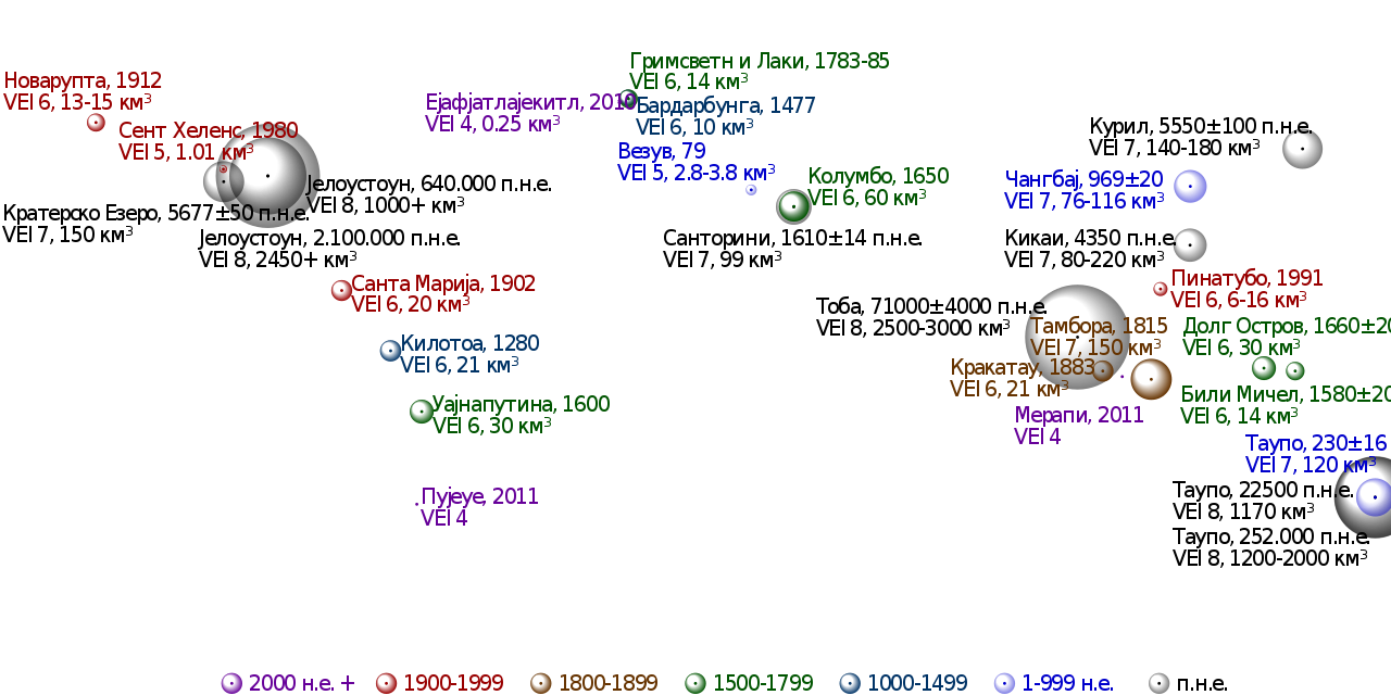
Македонски: Карта на најзначајни вулкански ерупции во светот. Експлозивноста е изразена со индекс на вулканска експлозивност (VEI), а зафатнината на исфрлениот материјал е претставена во кубни километри (км3).
English: Map in Macedonian of notable volcanic eruptions in the world. |
| Date | (UTC) |
| Source |
This file was derived from: Volcanic eruption map.svg: |
| Author |
|
| Other versions |
|

| This is a retouched picture, which means that it has been digitally altered from its original version. Modifications: Translated into Macedonian. The original can be viewed here: Volcanic eruption map.svg:
|
Licensing[edit]
I, the copyright holder of this work, hereby publish it under the following license:
This file is licensed under the Creative Commons Attribution-Share Alike 3.0 Unported license.
- You are free:
- to share – to copy, distribute and transmit the work
- to remix – to adapt the work
- Under the following conditions:
- attribution – You must give appropriate credit, provide a link to the license, and indicate if changes were made. You may do so in any reasonable manner, but not in any way that suggests the licensor endorses you or your use.
- share alike – If you remix, transform, or build upon the material, you must distribute your contributions under the same or compatible license as the original.
Original upload log[edit]
This image is a derivative work of the following images:
- File:Volcanic_eruption_map.svg licensed with Cc-by-sa-3.0
- 2012-07-13T12:38:09Z Cmglee 512x256 (370578 Bytes) Add Chixculub equivalent.
- 2012-07-12T23:35:47Z Cmglee 512x256 (369890 Bytes) Try uploading again.
- 2012-07-12T23:34:01Z Cmglee 512x256 (369850 Bytes) Reduce kerning.
- 2012-07-12T23:32:06Z Cmglee 512x256 (369850 Bytes) == {{int:filedesc}} == {{Information |Description={{en|1=Equirectangular projection of world land and ocean visible plus elevation data, in faded colours suitable as background for further data visualisation. Extracted from P
Uploaded with derivativeFX
File history
Click on a date/time to view the file as it appeared at that time.
| Date/Time | Thumbnail | Dimensions | User | Comment | |
|---|---|---|---|---|---|
| current | 01:14, 26 August 2012 | | 512 × 256 (362 KB) | Bjankuloski06en (talk | contribs) | == {{int:filedesc}} == {{Information |Description={{mk|1=Карта на најзначајни вулкански ерупции во светот. Експлозивноста е изразена со [[:... |
You cannot overwrite this file.
File usage on Commons
The following page uses this file: