File:Vitlyckehällen - KMB - 16001000035484.jpg
Jump to navigation
Jump to search
Size of this preview: 399 × 600 pixels. Other resolutions: 160 × 240 pixels | 527 × 792 pixels.
Original file (527 × 792 pixels, file size: 148 KB, MIME type: image/jpeg)
Captions
Captions
Add a one-line explanation of what this file represents
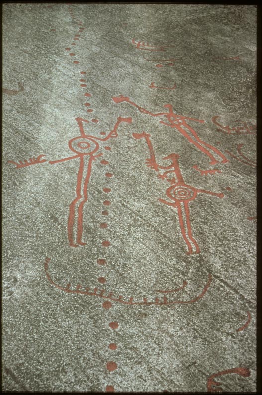
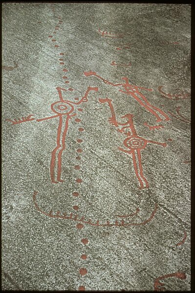
| Vitlyckehällen
( |
|||||||||||||||||||||||||||
|---|---|---|---|---|---|---|---|---|---|---|---|---|---|---|---|---|---|---|---|---|---|---|---|---|---|---|---|
| Photographer |
|
||||||||||||||||||||||||||
| Title |
Vitlyckehällen |
||||||||||||||||||||||||||
| Original caption |
Notera Av dokumentationsskäl har originalbeskrivningen från Riksantikvarieämbetet behållits. Tillrättalägganden och alternativa beskrivningar bör införas separat från nedanstående information. Vitlyckeristningen. Tanum 1:1.Felaktigheter kan även anmälas till denna sida. Motiv: Tanum 1:1 |
||||||||||||||||||||||||||
| Description |
Vitlyckeristningen. Tanum 1:1. Tanum 1:1.
|
||||||||||||||||||||||||||
| Depicted place | Sweden, Tanum Municipality, Q10690716 | ||||||||||||||||||||||||||
| Date | 1985 | ||||||||||||||||||||||||||
| Collection |
|
||||||||||||||||||||||||||
| Accession number | |||||||||||||||||||||||||||
| Source |
John-Eric Gustafsson / Kulturmiljöbild, Riksantikvarieämbetet
|
||||||||||||||||||||||||||
| Permission (Reusing this file) |
This file is licensed under the Creative Commons Attribution 2.5 Generic license. Attribution: John-Eric Gustafsson / Riksantikvarieämbetet
|
||||||||||||||||||||||||||


| Object location | | View this and other nearby images on: OpenStreetMap |
|---|
File history
Click on a date/time to view the file as it appeared at that time.
| Date/Time | Thumbnail | Dimensions | User | Comment | |
|---|---|---|---|---|---|
| current | 14:38, 11 July 2017 | | 527 × 792 (148 KB) | AndreCostaWMSE-bot (talk | contribs) | {{Kulturmiljöbild-image | short title = Vitlyckehällen | original description = Vitlyckeristningen. Tanum 1:1.<br> Motiv: Tanum 1:1<br> Kategori: Hällristning | wiki description = Vitlyckeristningen. Tanum 1:1. Tanum 1:1. {{Fornminne|10160600010001... |
You cannot overwrite this file.
File usage on Commons
The following 2 pages use this file: