File:Visual Timeline of World History By Land Area Conquered by Various Empires.png
Jump to navigation
Jump to search

Size of this preview: 800 × 450 pixels. Other resolutions: 320 × 180 pixels | 640 × 360 pixels | 1,024 × 576 pixels | 1,280 × 720 pixels | 2,560 × 1,440 pixels | 8,192 × 4,608 pixels.
Original file (8,192 × 4,608 pixels, file size: 22.92 MB, MIME type: image/png)
Captions
Captions
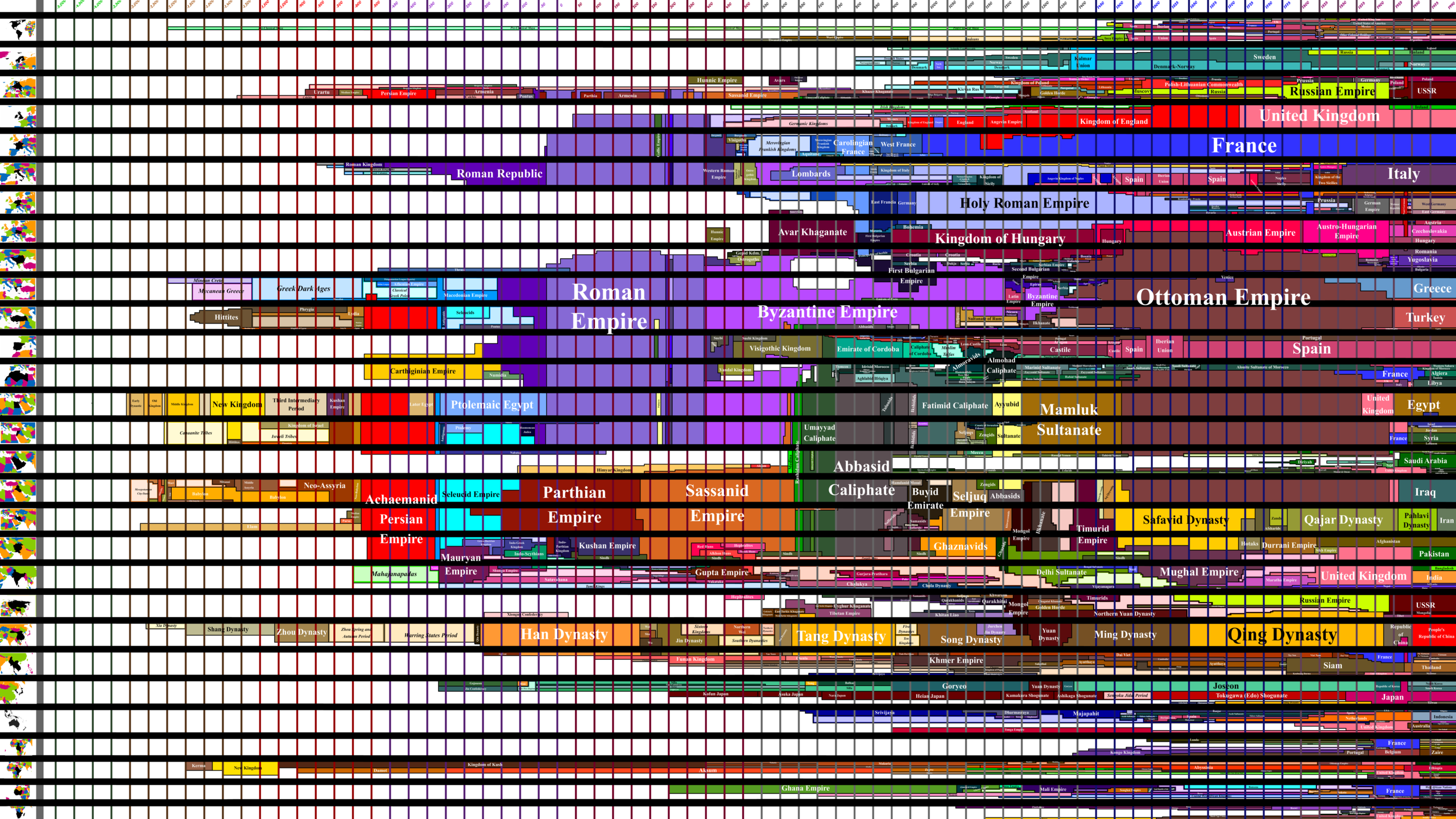
Display of World Empires from -6000 to 1990 by land area of a geographical region conquered.
Summary[edit]
| Description |
English: A visual representation of world empires. The X axis shows time, which intervals change as it goes from -6000 to 1990. The Y axis shows geographical regions. The more of a region an empire has conquered, the more it fills up its row. Opace boxes with outlines mean many states, often from a collapse of a previous empire (ie. Zhou Dynasty Warring States Period). |
| Date | |
| Source | Own work |
| Author | Acrrrrrrro |
Licensing[edit]
I, the copyright holder of this work, hereby publish it under the following license:
This file is licensed under the Creative Commons Attribution-Share Alike 4.0 International license.
- You are free:
- to share – to copy, distribute and transmit the work
- to remix – to adapt the work
- Under the following conditions:
- attribution – You must give appropriate credit, provide a link to the license, and indicate if changes were made. You may do so in any reasonable manner, but not in any way that suggests the licensor endorses you or your use.
- share alike – If you remix, transform, or build upon the material, you must distribute your contributions under the same or compatible license as the original.
File history
Click on a date/time to view the file as it appeared at that time.
| Date/Time | Thumbnail | Dimensions | User | Comment | |
|---|---|---|---|---|---|
| current | 13:55, 24 January 2022 | | 8,192 × 4,608 (22.92 MB) | Acrrrrrrro (talk | contribs) | Uploaded own work with UploadWizard |
You cannot overwrite this file.
File usage on Commons
There are no pages that use this file.