File:Vietnam's Mekong Delta ESA219993.jpg

Original file (2,000 × 1,949 pixels, file size: 1.84 MB, MIME type: image/jpeg)
Captions
Captions
Summary
[edit]
| Description |
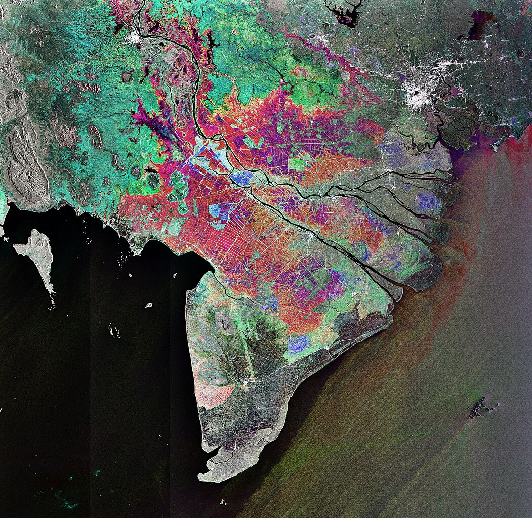
English: This Envisat image features Vietnam's Mekong Delta where the Mekong, the world's 12th longest river, fans out into tributaries and empties into the South China Sea in Southeast Asia.
Stretching from the glaciers of the Tibetan – Qinghai Plateau to the South China Sea, the Mekong River flows some 4000 km through six nations – China, Myanmar (Burma), Laos, Thailand, Cambodia and Vietnam. In addition to 1500 species of fish, the river is home to the Mekong giant catfish, which can reach a length of three metres and weigh up to 300 kg. It also hosts the endangered Irrawaddy Mekong dolphin. The 475 000 cubic km of water that the river discharges each year supplies the Mekong Delta's tropical wetlands with rich alluvial deposits. The wetlands act like sponges by storing and releasing water, making it ideal for rice cultivation. In fact, such an enormous amount of rice is produced in the Mekong Delta that it is often referred to as Vietnam's 'rice bowl'. The rice grown there feeds the rest of the country and produces enough to make Vietnam the world's third biggest rice exporter, after Thailand and India. Radar sensors, such as Envisat’s Advanced Synthetic Aperture Radar (ASAR), are particularly suited for monitoring rice cultivation because they are able to detect waterlogged ground and penetrate the humid cloud coverage typical of Asian rice-cultivating regions. Ho Chi Minh (formerly known as Saigon), Vietnam’s largest city and chief port, is visible as white in the upper right corner. The image was obtained by combining three ASAR acquisitions (9 January 2007, 13 February 2007 and 20 November 2007) taken over the same area. The colours in the image result from variations in the surface that occurred between acquisitions. |
| Date | |
| Source | http://www.esa.int/spaceinimages/Images/2009/04/Vietnam_s_Mekong_Delta |
| Author | European Space Agency |
| Permission (Reusing this file) |
ESA,CC BY-SA 3.0 IGO |
| Title | Vietnam's Mekong Delta |
| Set | Earth observation image of the week |
| System | Envisat ASAR |
| Mission | Envisat |
| Location | Vietnam |
| Activity | Observing the Earth |
| Keywords | Land use; Oceans and coastal zones; River delta |
Licensing
[edit]
- You are free:
- to share – to copy, distribute and transmit the work
- to remix – to adapt the work
- Under the following conditions:
- attribution – You must give appropriate credit, provide a link to the license, and indicate if changes were made. You may do so in any reasonable manner, but not in any way that suggests the licensor endorses you or your use.
- share alike – If you remix, transform, or build upon the material, you must distribute your contributions under the same or compatible license as the original.
File history
Click on a date/time to view the file as it appeared at that time.
| Date/Time | Thumbnail | Dimensions | User | Comment | |
|---|---|---|---|---|---|
| current | 16:07, 24 May 2017 | | 2,000 × 1,949 (1.84 MB) | Fæ (talk | contribs) | European Space Agency, Id 219993, http://www.esa.int/spaceinimages/Images/2009/04/Vietnam_s_Mekong_Delta, User:Fæ/Project_list/ESA |
You cannot overwrite this file.
File usage on Commons
There are no pages that use this file.