File:Vermilion Beach Map.jpg
Jump to navigation
Jump to search
No higher resolution available.
Vermilion_Beach_Map.jpg (300 × 236 pixels, file size: 11 KB, MIME type: image/jpeg)
Captions
Captions
Add a one-line explanation of what this file represents
| Description |
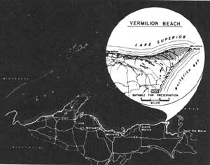
English: Vermilion beach extends 9 3/4 miles west of Whitefish Point, Michigan. |
|||
| Date | ||||
| Source | National Park Service Great Lakes Shoreline Recreation Area Survey, U.S. Department of Interior, National Park Service, “ Remaining Shoreline Opportunities in Minnesota, Wisconsin, Illinois, Indiana, Ohio, Michigan, Pennsylvania, New York”, National Park Service | |||
| Author | National Park Service | |||
| Permission (Reusing this file) |
|

File history
Click on a date/time to view the file as it appeared at that time.
| Date/Time | Thumbnail | Dimensions | User | Comment | |
|---|---|---|---|---|---|
| current | 12:17, 27 October 2008 | | 300 × 236 (11 KB) | Wpwatchdog (talk | contribs) | {{Information |Description={{en|1=Vermilion beach extends 8 miles west of Whitefish Point, Michigan.}} |Source=> National Park Service Great Lakes Shoreline Recreation Area Survey, U.S. Department of Interior, National Park Service, “ Remaining Shorelin |
You cannot overwrite this file.
File usage on Commons
There are no pages that use this file.
File usage on other wikis
The following other wikis use this file:
- Usage on en.wikipedia.org