File:Verlaufskarte Altefeld.png

Original file (1,131 × 697 pixels, file size: 1.25 MB, MIME type: image/png)
Captions
Captions
Summary[edit]
| Description |
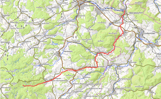
English: Course of Altefeld river in Hesse, Germany
Deutsch: Verlauf der Altefeld in Hessen |
|||||||||
| Date | ||||||||||
| Source | Own work | |||||||||
| Author | Kreuzschnabel; map data © OpenStreetMap contributors, map tiles by OpenTopoMap, CC-BY-SA | |||||||||
| Permission (Reusing this file) |
I, the copyright holder of this work, hereby publish it under the following license: This file is licensed under the Creative Commons Attribution-Share Alike 3.0 Unported license.
|


| Description |
This map was created from OpenStreetMap project data, collected by the community. This map may be incomplete, and may contain errors. Don't rely solely on it for navigation. |
|||
| Date | (see file history) | |||
| Source | openstreetmap.org | |||
| Creator |
OpenStreetMap contributors |
|||
| Permission (Reusing this file) |
OpenStreetMap data is available under the Open Database License (details). Map tiles are licensed under the Creative Commons Attribution-ShareAlike 2.0 license (CC-BY-SA 2.0).
This file is licensed under the Creative Commons Attribution-Share Alike 2.0 Generic license.
|
|||
| Georeferencing | If inappropriate please set warp_status = skip to hide. |
File history
Click on a date/time to view the file as it appeared at that time.
| Date/Time | Thumbnail | Dimensions | User | Comment | |
|---|---|---|---|---|---|
| current | 09:08, 23 September 2018 | | 1,131 × 697 (1.25 MB) | Kreuzschnabel (talk | contribs) | {{Information |description ={{en|1=Course of Altefeld river in Hesse, Germany}} {{de|1=Verlauf der Altefeld in Hessen}} |date =2018-09-23 |source ={{own}} |author =User:Kreuzschnabel; map data © OpenStreetMap contributors, map tiles by OpenTopoMap, CC-BY-SA |permission ={{subst:User:Kreuzschnabel/Lizenz}} }} {{Openstreetmap}} Category:Images by Kreuzschnabel/Karten und Grafiken Category:Altefeld (Fluss) Category:Maps of rivers of Hesse [[Category:O... |
You cannot overwrite this file.
File usage on Commons
The following 5 pages use this file:
File usage on other wikis
The following other wikis use this file:
- Usage on de.wikipedia.org
- Usage on www.wikidata.org