File:VIC-ASH-WEDNESDAY-MAP.png
Jump to navigation
Jump to search

Size of this preview: 800 × 559 pixels. Other resolutions: 320 × 224 pixels | 640 × 447 pixels | 816 × 570 pixels.
Original file (816 × 570 pixels, file size: 62 KB, MIME type: image/png)
Captions
Captions
Add a one-line explanation of what this file represents
Summary
[edit]
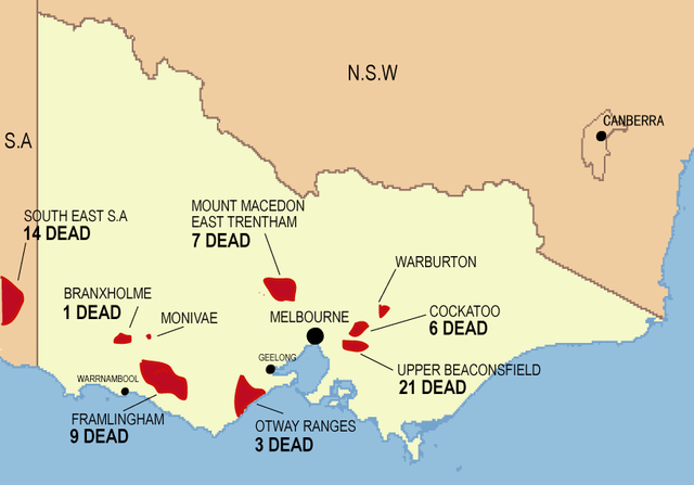
| Description | Indicative map of areas affected in Victoria by the 1983 Ash Wednesday fires |
| Date | |
| Source | Own work |
| Author | D.Murphy |
Licensing
[edit]
| I, the copyright holder of this work, release this work into the public domain. This applies worldwide. In some countries this may not be legally possible; if so: I grant anyone the right to use this work for any purpose, without any conditions, unless such conditions are required by law. |
File history
Click on a date/time to view the file as it appeared at that time.
| Date/Time | Thumbnail | Dimensions | User | Comment | |
|---|---|---|---|---|---|
| current | 09:32, 21 February 2008 | | 816 × 570 (62 KB) | Admella1859~commonswiki (talk | contribs) | {{Information |Description= Indicative map of areas affected in Victoria by the 1983 Ash Wednesday fires |Source=self-made |Date= 21st February 2008 |Author= D.Murphy |Permission= |other_versions= }} |
You cannot overwrite this file.
File usage on Commons
The following page uses this file:
File usage on other wikis
The following other wikis use this file:
- Usage on de.wikipedia.org
- Usage on en.wikipedia.org
- Usage on fr.wikipedia.org
- Usage on ru.wikipedia.org
- Usage on www.wikidata.org