File:Utrecht1865.png
Original file (1,577 × 1,379 pixels, file size: 234 KB, MIME type: image/png)
Captions
Summary[edit]
DescriptionUtrecht1865.png |
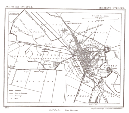
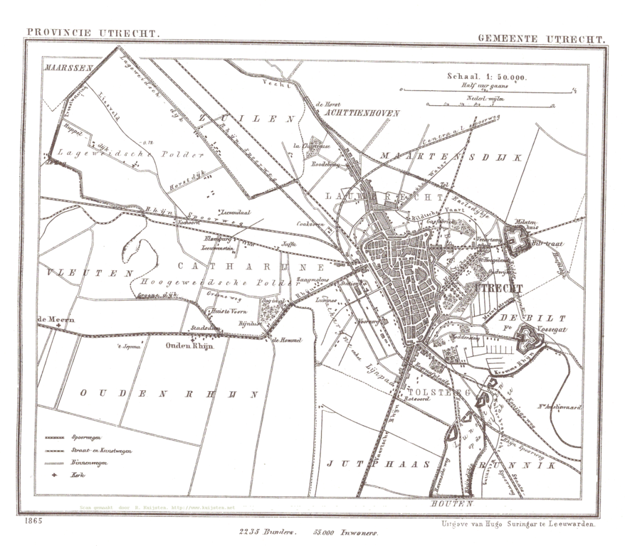
Nederlands: De afbeelding komt van http://www.atlas1868.nl/ut/ . Het is de kaart van de gemeente Utrecht.
This image came from: http://www.atlas1868.nl/ut/ . It is the map of gemeente Utrecht. |
Date | 3 April 2005 (original upload date) |
Source | Transferred from nl.wikipedia |
Author | Original uploader was Jeroen at nl.wikipedia |
Permission (Reusing this file) |
This image is in the public domain; PD-REDEN. |
Licensing[edit]
Public domainPublic domainfalsefalse |
This work is in the public domain in its country of origin and other countries and areas where the copyright term is the author's life plus 70 years or fewer. You must also include a United States public domain tag to indicate why this work is in the public domain in the United States. Note that a few countries have copyright terms longer than 70 years: Mexico has 100 years, Jamaica has 95 years, Colombia has 80 years, and Guatemala and Samoa have 75 years. This image may not be in the public domain in these countries, which moreover do not implement the rule of the shorter term. Honduras has a general copyright term of 75 years, but it does implement the rule of the shorter term. Copyright may extend on works created by French who died for France in World War II (more information), Russians who served in the Eastern Front of World War II (known as the Great Patriotic War in Russia) and posthumously rehabilitated victims of Soviet repressions (more information). | |
This file has been identified as being free of known restrictions under copyright law, including all related and neighboring rights. |
https://creativecommons.org/publicdomain/mark/1.0/PDMCreative Commons Public Domain Mark 1.0falsefalse
This image contains digital watermarking or credits in the image itself. The usage of visible watermarks is discouraged. If a non-watermarked version of the image is available, please upload it under the same file name and then remove this template. Ensure that removed information is present in the image description page and replace this template with {{Metadata from image}} or {{Attribution metadata from licensed image}}.
Caution: Before removing a watermark from a copyrighted image, please read the WMF's analysis of the legal ramifications of doing so, as well as Commons' proposed policy regarding watermarks. If the old version is still useful, for example if removing the watermark damages the image significantly, upload the new version under a different title so that both can be used. After uploading the non-watermarked version, replace this template with{{Superseded|new filename|version without watermarks}} .Bahasa Indonesia ∙ italiano ∙ eesti ∙ sicilianu ∙ Deutsch ∙ català ∙ magyar ∙ čeština ∙ română ∙ español ∙ português ∙ English ∙ hrvatski ∙ Plattdüütsch ∙ français ∙ Nederlands ∙ polski ∙ galego ∙ slovenščina ∙ suomi ∙ svenska ∙ Ελληνικά ∙ беларуская (тарашкевіца) ∙ български ∙ македонски ∙ русский ∙ українська ∙ മലയാളം ∙ ไทย ∙ 日本語 ∙ 中文 ∙ 中文(简体) ∙ 中文(繁體) ∙ עברית ∙ العربية ∙ فارسی ∙ +/− |
Original upload log[edit]
- 2005-04-03 16:46 Jeroen 1577×1379×4 (239647 bytes) {{beperkt}} Deze afbeelding kan alleen worden gebruikt op wikipedia. De naam van de website waar het vandaan kwam moet worden vermeld. De afbeelding komt van http://www.atlas1868.nl/ut/ . Het is de kaart van de gemeente [[Utrecht]]. This image
File history
Click on a date/time to view the file as it appeared at that time.
Date/Time | Thumbnail | Dimensions | User | Comment | |
---|---|---|---|---|---|
current | 17:08, 14 March 2008 | 1,577 × 1,379 (234 KB) | File Upload Bot (Magnus Manske) (talk | contribs) | {{BotMoveToCommons|nl.wikipedia}} {{Information |Description={{nl|De afbeelding komt van http://www.rat.de/kuijsten/atlas/ut/ . Het is de kaart van de gemeente Utrecht. This image came from: http://www.rat.de/kuijsten/atlas/ut/ . |
You cannot overwrite this file.
File usage on Commons
There are no pages that use this file.