File:Ustrinum di tipo circolare - Battaglia del Trasimeno.jpg
Jump to navigation
Jump to search

Size of this preview: 800 × 570 pixels. Other resolutions: 320 × 228 pixels | 640 × 456 pixels | 1,024 × 729 pixels | 1,302 × 927 pixels.
Original file (1,302 × 927 pixels, file size: 802 KB, MIME type: image/jpeg)
Captions
Captions
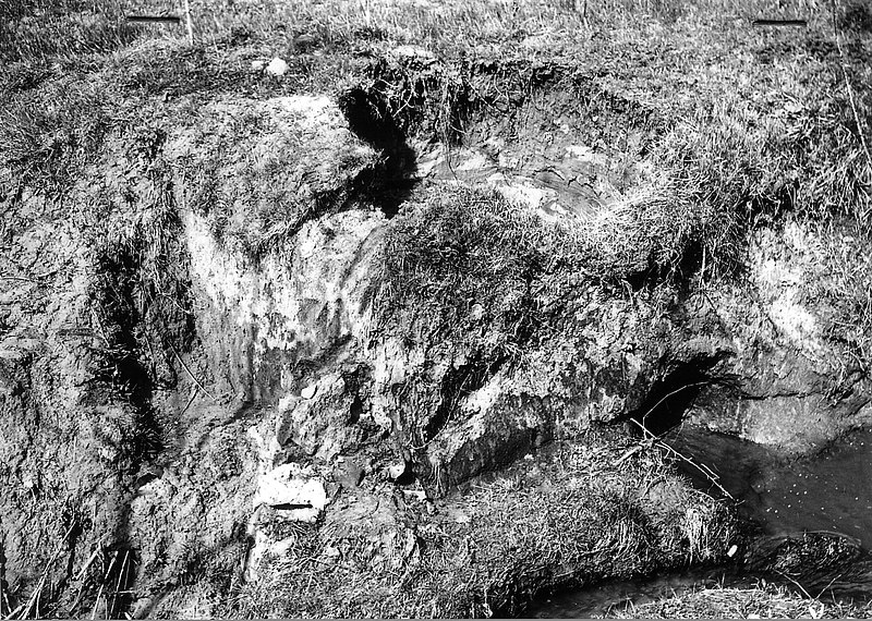
rounded shape ustrinum (crematorium) from the Battle of Trasimene
Summary[edit]
| Description |
Italiano: Ustrinum (lat. - forno crematorio) di forma circolare sito nella valle di Sanguineto - Tuoro s/T - fotografato dal Prof. Giancarlo Susini nel 1959 e da lui attribuito come opera eseguita al termine della battaglia del Trasimeno. Il manufatto era ricolmo di ceneri organiche e ricoperto da un tumulo. Sono state ritrovate, frammiste alle ceneri, punte di frecce e la punta di un pilum.
Nella valle ne sono stati censiti circa 16 di questo tipo, all'inizio degli anni '60. I due principali (uno in via del Fornello e l'altro presso il Palazzo del Capra - Centro di documentazione della Battaglia del Trasimeno) sono stati consolidati con muratura e sono tuttora visibili. Dimensioni medie del secondo sono 6,18 mt di profondità e 4,32 mt di diametro. Per maggiori informazioni si veda Susini G., Ricerche sulla battaglia del Trasimeno, Accademia Etrusca di Cortona, Annuatio XI, nuova serie Vol. IV, 1960, pagg. 84-89 |
| Date | |
| Source | Archivio municipale del Comune di Tuoro sul Trasimeno |
| Author | Prof. Giancarlo Susini |
| Permission (Reusing this file) |
| Camera location | | View this and other nearby images on: OpenStreetMap |
|---|
Licensing[edit]
This file is licensed under the Creative Commons Attribution-Share Alike 4.0 International license.
- You are free:
- to share – to copy, distribute and transmit the work
- to remix – to adapt the work
- Under the following conditions:
- attribution – You must give appropriate credit, provide a link to the license, and indicate if changes were made. You may do so in any reasonable manner, but not in any way that suggests the licensor endorses you or your use.
- share alike – If you remix, transform, or build upon the material, you must distribute your contributions under the same or compatible license as the original.
File history
Click on a date/time to view the file as it appeared at that time.
| Date/Time | Thumbnail | Dimensions | User | Comment | |
|---|---|---|---|---|---|
| current | 14:02, 28 February 2019 | | 1,302 × 927 (802 KB) | Oracolodidelfi (talk | contribs) | User created page with UploadWizard |
You cannot overwrite this file.
File usage on Commons
There are no pages that use this file.
File usage on other wikis
The following other wikis use this file:
- Usage on es.wikipedia.org
- Usage on it.wikipedia.org