File:Urban Renewal District and Fort Stanwix (1ccaad3c-c4e4-6c37-dba2-3955b23328a0).JPG
Jump to navigation
Jump to search
No higher resolution available.
Urban_Renewal_District_and_Fort_Stanwix_(1ccaad3c-c4e4-6c37-dba2-3955b23328a0).JPG (690 × 494 pixels, file size: 89 KB, MIME type: image/jpeg)
Captions
Captions
Add a one-line explanation of what this file represents

|
The categories of this image need checking. You can do so here.
|
.JPG&action=edit&withJS=MediaWiki:Catcheck.js)
Summary
[edit].JPG&action=edit§ion=1)
| English: Urban Renewal District and Fort Stanwix | ||||
|---|---|---|---|---|
| Photographer |
English: NPS |
|||
| Title |
English: Urban Renewal District and Fort Stanwix |
|||
| Publisher |
English: U.S. National Park Service |
|||
| Description |
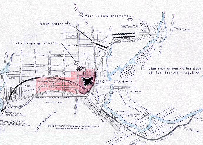
English: A portion of a street map is highlighted in red. Fort Stanwix. A map from the Fort Stanwix Master Plan shows the area of the Urban Renewal District and Fort Stanwix in Rome, New York. Massive urban renewal projects began in the town in the 1960, including the reconstruction of Fort Stanwix.
|
|||
| Depicted place |
English: 43.21148, -75.45718; Fort Stanwix National Monument, Oneida County, New York; Latitude: 43.2104988098145, Longitude: -75.4555969238281 |
|||
| Accession number | ||||
| Source |
English: NPGallery |
|||
| Permission (Reusing this file) |
|
|||
| NPS Unit Code | FOST | |||
| Album(s) | English: Fort Stanwix |
|||
File history
Click on a date/time to view the file as it appeared at that time.
| Date/Time | Thumbnail | Dimensions | User | Comment | |
|---|---|---|---|---|---|
| current | 21:50, 10 May 2024 | | 690 × 494 (89 KB) | BMacZeroBot (talk | contribs) | Batch upload (Commons:Batch uploading/NPGallery) |
You cannot overwrite this file.
File usage on Commons
There are no pages that use this file.
.JPG&oldid=875690338)