File:United Nations geographical subregions de.svg
Jump to navigation
Jump to search

Size of this PNG preview of this SVG file: 800 × 406 pixels. Other resolutions: 320 × 162 pixels | 640 × 325 pixels | 1,024 × 520 pixels | 1,280 × 650 pixels | 2,560 × 1,299 pixels | 940 × 477 pixels.
Original file (SVG file, nominally 940 × 477 pixels, file size: 1.67 MB)
Captions
Captions
Add a one-line explanation of what this file represents
Summary
[edit]| Description |
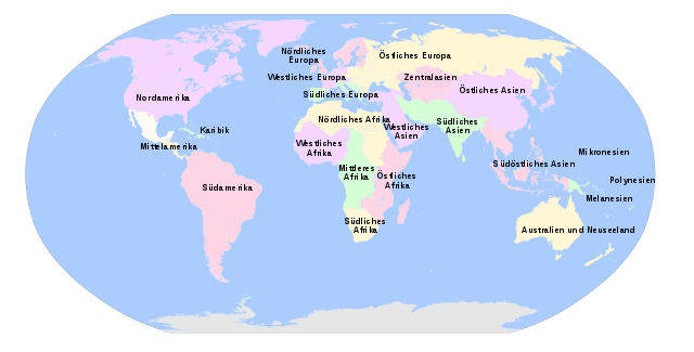
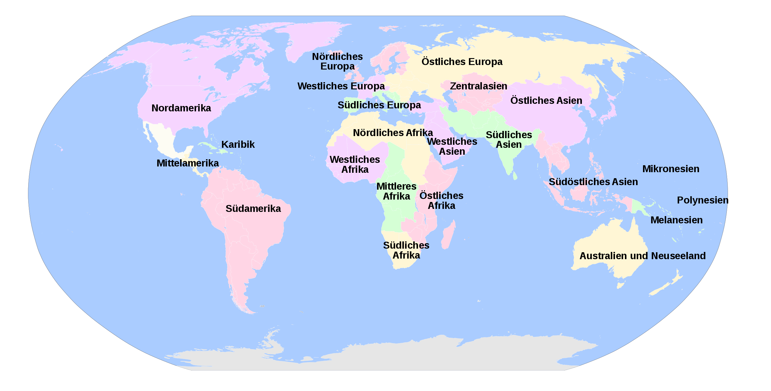
English: United Nations geographical subregions. Labelled in German. Own work, using File:BlankMap-World6.svg. Information according to File:United Nations geographical subregions.png and http://unstats.un.org/unsd/methods/m49/m49regin.htm. Deutsch: Geographische Unterregionen laut Einteilung der Vereinigten Nationen. Beschriftung auf Deutsch. Eigene Arbeit unter Benutzung der Datei File:BlankMap-World6.svg. Information laut File:United Nations geographical subregions.png und http://unstats.un.org/unsd/methods/m49/m49regin.htm. |
| Date | |
| Source | Own work |
| Author | T.seppelt |
| Other versions |
|


| This is a retouched picture, which means that it has been digitally altered from its original version. Modifications: Translated to German. The original can be viewed here: Geografiaj subregionoj laŭ Unuiĝintaj Nacioj eo.svg:
|
Licensing
[edit]
I, the copyright holder of this work, hereby publish it under the following license:
This file is licensed under the Creative Commons Attribution-Share Alike 4.0 International license.
- You are free:
- to share – to copy, distribute and transmit the work
- to remix – to adapt the work
- Under the following conditions:
- attribution – You must give appropriate credit, provide a link to the license, and indicate if changes were made. You may do so in any reasonable manner, but not in any way that suggests the licensor endorses you or your use.
- share alike – If you remix, transform, or build upon the material, you must distribute your contributions under the same or compatible license as the original.
File history
Click on a date/time to view the file as it appeared at that time.
| Date/Time | Thumbnail | Dimensions | User | Comment | |
|---|---|---|---|---|---|
| current | 18:36, 26 July 2016 | | 940 × 477 (1.67 MB) | T.seppelt (talk | contribs) | fixing mistakes [http://millenniumindicators.un.org/unsd/methods/m49/m49regin.htm#americas] |
| 09:04, 3 October 2014 |  | 940 × 477 (1.67 MB) | T.seppelt (talk | contribs) | User created page with UploadWizard |
You cannot overwrite this file.
File usage on Commons
The following 6 pages use this file:
- File:Geografiaj subregionoj laŭ Unuiĝintaj Nacioj eo.svg
- File:Geografiaj subregionoj laŭ Unuiĝintaj Nacioj hr.svg
- File:United Nations geographical subregions en.svg
- File:United Nations geographical subregions ja.svg
- File:United Nations geographical subregions lv.svg
- File:Географски подрегиони на светот според ООН.svg
File usage on other wikis
The following other wikis use this file:
- Usage on de.wikipedia.org
- Usage on es.wikipedia.org
- Usage on www.wikidata.org