File:Una cruz del altar en el campo - Ermita de Santa Ana ( Asturias ) (20423966332).jpg

Original file (4,000 × 3,000 pixels, file size: 4.51 MB, MIME type: image/jpeg)
Captions
Captions
Summary[edit]
_(20423966332).jpg&action=edit§ion=1)
| Description |
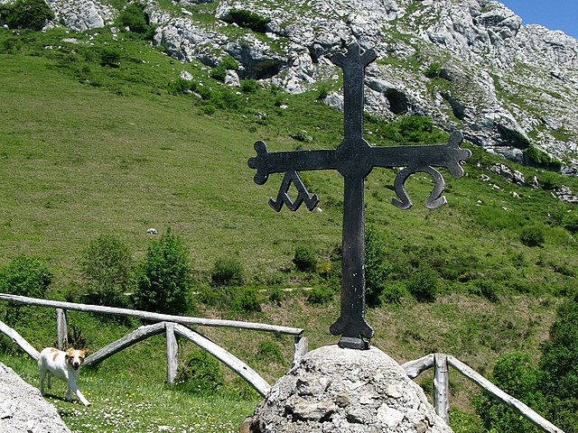
Español: Los Puertos de Marabio se encuentran entre los concejos de Yernes y Tameza, Teverga y Proaza, y están delimitados al este por la sierra de Peña Padiella, al oeste por la Sierra de la Granda, al norte por el Pico Caldoveiro y al sur por la divisoria de aguas del río Santibáñez.
Es un espacio natural protegido por la existencia de un peculiar complejo kárstico, formado por dolinas y valles ciegos que le dan un gran interés hidrogeológico. Una de las cruces del altar en el campo de la ermita de Santa Ana, la cruz de la victoria o de Asturias es símbolo de la victoria de Don Pelayo en la batalla de Covadonga. Las letras griegas alfa y omega simbolizan que Dios es principio y fin de todas las cosas Jovellanos tras pasar por los puertos de La Mesa y La Madalena, bajo por Alesga a descansar en Entrago y, al día siguiente, para continuar por esa vía histórica en dirección a Gijón, subió otra vez a la Calzada de La Mesa, desde Entrago, por la "calzadina" que iba a Santa Ana de Marabio, este pequeño camino, o “caleyón”, o “calzadina” de origen romano (o más bien Prehistórico, acondicionado en época romana), del pueblo de Entrago a los puertos de Marabio. Se esta perdiendo por la maleza, pues nadie lo cuida. Ni siquiera esta catalogado o estudiado Se trata de adivinar el lugar de la fotografia..... |
| Date | |
| Source | https://www.flickr.com/photos/70626035@N00/20423966332/ |
| Author | jacilluch |
| Flickr sets |
|
| Flickr pools |
|
| Flickr tags |
|
| Flickr posted date | 9 August 2015 |
| Camera location | | View this and other nearby images on: OpenStreetMap |
|---|
_(20423966332).jpg¶ms=043.199247_N_-006.110876_E_globe:Earth_type:camera__&language=en)
Licensing[edit]
_(20423966332).jpg&action=edit§ion=2)
- You are free:
- to share – to copy, distribute and transmit the work
- to remix – to adapt the work
- Under the following conditions:
- attribution – You must give appropriate credit, provide a link to the license, and indicate if changes were made. You may do so in any reasonable manner, but not in any way that suggests the licensor endorses you or your use.
- share alike – If you remix, transform, or build upon the material, you must distribute your contributions under the same or compatible license as the original.
| This image was originally posted to Flickr by jacilluch at https://flickr.com/photos/70626035@N00/20423966332 (archive). It was reviewed on 28 December 2018 by FlickreviewR 2 and was confirmed to be licensed under the terms of the cc-by-sa-2.0. |
File history
Click on a date/time to view the file as it appeared at that time.
| Date/Time | Thumbnail | Dimensions | User | Comment | |
|---|---|---|---|---|---|
| current | 00:56, 28 December 2018 | | 4,000 × 3,000 (4.51 MB) | Discasto (talk | contribs) | == {{int:filedesc}} == {{information |description={{es|1=Los Puertos de Marabio se encuentran entre los concejos de Yernes y Tameza, Teverga y Proaza, y están delimitados al este por la sierra de Peña Padiella, al oeste por la Sierra de la Granda, al norte por el Pico Caldoveiro y al sur por la divisoria de aguas del río Santibáñez. Es un espacio natural protegido por la existencia de un peculiar complejo kárstico, formado por dolinas y valles ciegos que le dan un gran interés hidrogeológico.... |
You cannot overwrite this file.
File usage on Commons
There are no pages that use this file.
_(20423966332).jpg&oldid=811490910)