File:US.EEZ Pacific centered NOAA map.png
Jump to navigation
Jump to search
Size of this preview: 699 × 600 pixels. Other resolutions: 280 × 240 pixels | 559 × 480 pixels | 754 × 647 pixels.
Original file (754 × 647 pixels, file size: 149 KB, MIME type: image/png)
Captions
Captions
Add a one-line explanation of what this file represents

|
File:NOAA Map of the US EEZ.svg is a vector version of this file. It should be used in place of this PNG file when not inferior.
File:US.EEZ Pacific centered NOAA map.png → File:NOAA Map of the US EEZ.svg
For more information, see Help:SVG. |
 |
Summary[edit]
| Description |
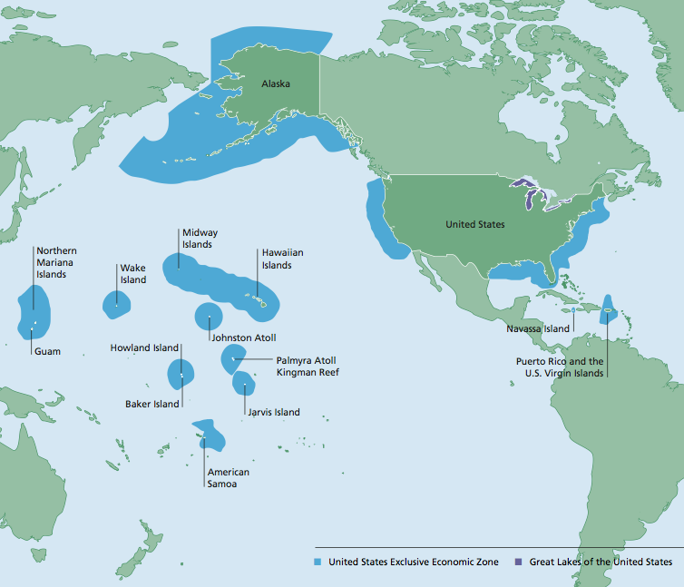
English: United States Exclusive Economic Zone - Pacific centered NOAA map |
| Date | |
| Source | http://www.gc.noaa.gov/documents/2011/012711_gcil_maritime_eez_map.pdf |
| Author | National Oceanic and Atmospheric Administration |
Licensing[edit]
This image is in the public domain because it contains materials that originally came from the U.S. National Oceanic and Atmospheric Administration, taken or made as part of an employee's official duties.
|
File history
Click on a date/time to view the file as it appeared at that time.
| Date/Time | Thumbnail | Dimensions | User | Comment | |
|---|---|---|---|---|---|
| current | 14:47, 17 August 2015 | | 754 × 647 (149 KB) | TheVirginiaHistorian (talk | contribs) | User created page with UploadWizard |
You cannot overwrite this file.
File usage on Commons
There are no pages that use this file.
File usage on other wikis
The following other wikis use this file:
- Usage on az.wikipedia.org
- Usage on en.wikipedia.org
- Usage on id.wikipedia.org
- Usage on ru.wikipedia.org
- Usage on sd.wikipedia.org
- Usage on th.wikipedia.org