File:U.S. 2016 to 2020 presidential election swing.svg
Jump to navigation
Jump to search

Size of this PNG preview of this SVG file: 555 × 352 pixels. Other resolutions: 320 × 203 pixels | 640 × 406 pixels | 1,024 × 649 pixels | 1,280 × 812 pixels | 2,560 × 1,624 pixels.
Original file (SVG file, nominally 555 × 352 pixels, file size: 1,018 KB)
Captions
Captions
Add a one-line explanation of what this file represents
Summary
[edit]
| Description |
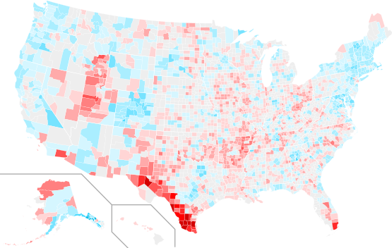
English: Swing in county margins from United States presidential election (2016) to United States presidential election (2020).
Democratic—+>15%
Democratic—+12.5-15%
Democratic—+10-12.5%
Democratic—+7.5-10%
Democratic—+5-7.5%
Democratic—+2.5-5%
Democratic—+<2.5%
<2%
Republican—+<2.5%
Republican—+2.5-5%
Republican—+5-7.5%
Republican—+7.5-10%
Republican—+10-12.5%
Republican—+12.5-15%
Republican—+>15%
Data unavailable |
| Date | See below. |
| Source |
This file was derived from: USA Counties with names.svg |
| Author | Magog the Ogre |
Licensing
[edit]
I, the copyright holder of this work, hereby publish it under the following license:
| This file is made available under the Creative Commons CC0 1.0 Universal Public Domain Dedication. | |
| The person who associated a work with this deed has dedicated the work to the public domain by waiving all of their rights to the work worldwide under copyright law, including all related and neighboring rights, to the extent allowed by law. You can copy, modify, distribute and perform the work, even for commercial purposes, all without asking permission.
|
| Annotations | This image is annotated: View the annotations at Commons |
File history
Click on a date/time to view the file as it appeared at that time.
| Date/Time | Thumbnail | Dimensions | User | Comment | |
|---|---|---|---|---|---|
| current | 21:56, 23 June 2022 | | 555 × 352 (1,018 KB) | Ngfsmg (talk | contribs) | State lines length |
| 00:07, 13 November 2021 |  | 555 × 352 (1,018 KB) | Yet another newcomer (talk | contribs) | Added Alaska county swings from Dave's Redistricting | |
| 02:08, 18 December 2020 |  | 555 × 352 (925 KB) | Magog the Ogre (talk | contribs) | weekly update 12/14 | |
| 22:47, 7 December 2020 |  | 555 × 352 (925 KB) | Magog the Ogre (talk | contribs) | weekly update 12/6 | |
| 00:59, 29 November 2020 |  | 555 × 352 (925 KB) | Magog the Ogre (talk | contribs) | weekly update from upstream data | |
| 23:03, 28 November 2020 |  | 555 × 352 (924 KB) | Magog the Ogre (talk | contribs) | Use both parties swing, not just winner | |
| 13:41, 22 November 2020 |  | 555 × 352 (924 KB) | Magog the Ogre (talk | contribs) | update to 2020 data set 0.5 | |
| 04:40, 10 November 2020 |  | 555 × 352 (925 KB) | Magog the Ogre (talk | contribs) | daily update | |
| 04:33, 9 November 2020 |  | 555 × 352 (925 KB) | Magog the Ogre (talk | contribs) | {{Information |description={{en|1=Swing in county margins from United States presidential election (2016) to United States presidential election (2020). {{legend|#00a1c8|Democratic—+>30%}} {{legend|#00bdec|Democratic—+25-30%}} {{legend|#09ceff|Democratic—+20-25%}} {{legend|#4bdbff|Democratic—+15-20%}} {{legend|#77e3ff|Democratic—+10-15%}} {{legend|#AAEEFF|Democratic—+5-10%}} {{legend|#D5F6FF|Democr... |
You cannot overwrite this file.
File usage on Commons
The following 6 pages use this file:
- User:Magog the Ogre/Political maps/2020 December 1-10
- User:Magog the Ogre/Political maps/2020 December 11-20
- User:Magog the Ogre/Political maps/2020 November 1-10
- User:Magog the Ogre/Political maps/2020 November 21-30
- User:Magog the Ogre/Political maps/2021 November 11-20
- User:Magog the Ogre/Political maps/2022 June 21-30
File usage on other wikis
The following other wikis use this file:
- Usage on en.wikipedia.org
- Usage on he.wikipedia.org
- Usage on it.wikipedia.org
- Usage on ko.wikipedia.org
- Usage on no.wikipedia.org