File:TuVM Stade, scale model of Flugplatz Stade, cropped.jpg
Jump to navigation
Jump to search

Size of this preview: 800 × 469 pixels. Other resolutions: 320 × 188 pixels | 640 × 375 pixels | 1,024 × 600 pixels | 1,280 × 750 pixels | 2,560 × 1,501 pixels | 3,982 × 2,334 pixels.
Original file (3,982 × 2,334 pixels, file size: 2.25 MB, MIME type: image/jpeg)
Captions
Captions
Add a one-line explanation of what this file represents
Summary
[edit]
| Description |
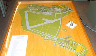
Deutsch: Modell des Flugplatzes Stade von Dieter-Theodor Bohlmann im Technik- und Verkehrsmuseum Stade. Maßstab 1:2000; dargestellter Ausbauzustand wie im November 1943. English: Scale model of Flugplatz Stade by Dieter-Theodor Bohlmann at the Technik- und Verkehrsmuseum Stade. Scale is 1:2000, airfield and installations shown as they were in November 1943.
Annotations: FLUGPLATZ STADE Ausbauzustand November 1943 Rekonstruktion M(aßstab) 1:2000 von Dieter-Theodor Bohlmann nach Lageplänen 1939 und 1945 sowie nach Luftaufnahmen der RAF vom 5. November 1943 Die Bauwerke und ihre Funktionen: 1. Mannschafts- und Offiziersunterkunftskasernen 2. Gärtnerei 3. Motorenwerkstatt 4. Bauarbeiterlager 5. Kleinkaliber-Schießstand 6. Sportplatz 7. Exerzier- und Sporthallen 8. Fernmeldebunker 9. Hauptwache mit Gefängnis 10. Kommandantur 11. Kantinen 12. Fahrbereitschaft 13. Waffenmeisterei 14. Flugleitung mit Platzfeuerwehr 15. Flugzeughallen 16. Wasserwerk 17. Lehrgebäude 18. Vorkommandogebäude 19. Krankenrevier 20. Funkmeisterei 21. Kfz-Halle und Exerzierplatz 22. Kraftfahrkommando mit Garagen, Werkstätten und Übungsplatz 23. Wache 24. Bauleitung und Kasino 25. Bahnhof mit Lagerhaus und Lokomotivschuppen 26. Flugzeugwerft 27. Kompensationsdrehscheibe 28. Dienstwohnungen 29. Funkpeilgebäude 30. Startbahn mit 1000 m Länge 31. Startbahn mit 1200 m Länge 32. Roll- und Verbindungsbahnen 33. Holzhallen 34. Flugzeug-Schießstand 35. Splitterboxen 36. Munitionslager 37. Flakstände 38. Tarnstraßen |
| Date | |
| Source | Own work |
| Author | Morn |
Licensing
[edit]
I, the copyright holder of this work, hereby publish it under the following licenses:
This file is licensed under the Creative Commons Attribution-Share Alike 3.0 Unported license.
- You are free:
- to share – to copy, distribute and transmit the work
- to remix – to adapt the work
- Under the following conditions:
- attribution – You must give appropriate credit, provide a link to the license, and indicate if changes were made. You may do so in any reasonable manner, but not in any way that suggests the licensor endorses you or your use.
- share alike – If you remix, transform, or build upon the material, you must distribute your contributions under the same or compatible license as the original.

|
Permission is granted to copy, distribute and/or modify this document under the terms of the GNU Free Documentation License, Version 1.2 or any later version published by the Free Software Foundation; with no Invariant Sections, no Front-Cover Texts, and no Back-Cover Texts. A copy of the license is included in the section entitled GNU Free Documentation License. |
You may select the license of your choice.
| Annotations | This image is annotated: View the annotations at Commons |
File history
Click on a date/time to view the file as it appeared at that time.
| Date/Time | Thumbnail | Dimensions | User | Comment | |
|---|---|---|---|---|---|
| current | 13:52, 11 March 2012 | | 3,982 × 2,334 (2.25 MB) | Morn (talk | contribs) | == {{int:filedesc}} == {{Information |Description={{de|Modell des Flugplatzes Stade von Dieter-Theodor Bohlmann im Technik- und Verkehrsmuseum Stade. Maßstab 1:2000; dargestellter Ausbauzustand wie im November 1943.}}{{en|Scale model of Flugplatz Stad... |
You cannot overwrite this file.
File usage on Commons
The following page uses this file:
File usage on other wikis
The following other wikis use this file:
- Usage on de.wikipedia.org