File:Tsarap Upstream Phuktal Zanskar Oct22 R16 06699.jpg
Jump to navigation
Jump to search

Size of this preview: 800 × 533 pixels. Other resolutions: 320 × 213 pixels | 640 × 427 pixels | 1,024 × 683 pixels | 1,280 × 853 pixels | 2,560 × 1,707 pixels | 5,472 × 3,648 pixels.
Original file (5,472 × 3,648 pixels, file size: 16.05 MB, MIME type: image/jpeg)
Captions
Captions
Add a one-line explanation of what this file represents
Summary[edit]
| Description |
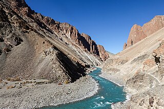
English: Tsarap River, view upstream, path Purney to Phuktal on the right. Elev. 3,810 m (12,500 ft). Zanskar, Ladakh, India |
|||
| Date | ||||
| Source | Own work | |||
| Author |
|

| Camera location | | View this and other nearby images on: OpenStreetMap |
|---|
|
The geographical information in this file was retrospectively estimated.
The location may therefore be somewhat imprecise. Verifying and refining these coordinates is strongly encouraged. |
Licensing[edit]
I, the copyright holder of this work, hereby publish it under the following license:
This file is licensed under the Creative Commons Attribution-Share Alike 4.0 International license.
- You are free:
- to share – to copy, distribute and transmit the work
- to remix – to adapt the work
- Under the following conditions:
- attribution – You must give appropriate credit, provide a link to the license, and indicate if changes were made. You may do so in any reasonable manner, but not in any way that suggests the licensor endorses you or your use.
- share alike – If you remix, transform, or build upon the material, you must distribute your contributions under the same or compatible license as the original.
This image has been assessed using the Quality image guidelines and is considered a Quality image.
|
File history
Click on a date/time to view the file as it appeared at that time.
| Date/Time | Thumbnail | Dimensions | User | Comment | |
|---|---|---|---|---|---|
| current | 05:04, 20 August 2023 | | 5,472 × 3,648 (16.05 MB) | Tagooty (talk | contribs) | c:User:Rillke/bigChunkedUpload.js: NR of sky and river redone using LR sky/colour mask |
| 02:58, 20 August 2023 |  | 5,472 × 3,648 (16.07 MB) | Tagooty (talk | contribs) | c:User:Rillke/bigChunkedUpload.js: NR sky near mountains on right | |
| 16:00, 19 August 2023 |  | 5,472 × 3,648 (16.04 MB) | Tagooty (talk | contribs) | c:User:Rillke/bigChunkedUpload.js: NR sky, water | |
| 05:24, 19 August 2023 |  | 5,472 × 3,648 (17.3 MB) | Tagooty (talk | contribs) | c:User:Rillke/bigChunkedUpload.js: Sharpening, clarity | |
| 03:39, 19 August 2023 |  | 5,472 × 3,648 (16.26 MB) | Tagooty (talk | contribs) | c:User:Rillke/bigChunkedUpload.js: Exposure, sharpen | |
| 16:13, 11 August 2023 |  | 5,472 × 3,648 (12.71 MB) | Tagooty (talk | contribs) | Uploaded own work with UploadWizard |
You cannot overwrite this file.
File usage on Commons
The following 14 pages use this file:
- User talk:Tagooty/Archive of User talk:Tagooty 13 Aug 2023 to 30 Nov 2023
- Commons:Featured picture candidates/File:Tsarap Upstream Phuktal Zanskar Oct22 R16 06699.jpg
- Commons:Featured picture candidates/Log/August 2023
- Commons:Featured pictures/Places/Natural
- Commons:Featured pictures/chronological/2023-B
- Commons:Featured pictures/chronological/August 2023
- Commons:Picture of the Year/2023/Candidates
- Commons:Picture of the Year/2023/R1/Gallery/2023-B
- Commons:Picture of the Year/2023/R1/Gallery/ALL
- Commons:Picture of the Year/2023/R1/Gallery/M08
- Commons:Picture of the Year/2023/R1/Gallery/Waters
- Commons:Quality images/Subject/Places/Natural structures/archive 2023
- Commons:Quality images candidates/Archives August 20 2023
- File:Tsarap Upstream Phuktal Zanskar Oct22 R16 06699.jpg
File usage on other wikis
The following other wikis use this file:
- Usage on de.wikipedia.org
- Usage on en.wikipedia.org