File:Trpimirjeva Hrvaska.PNG
Jump to navigation
Jump to search

Size of this preview: 800 × 532 pixels. Other resolutions: 320 × 213 pixels | 640 × 425 pixels | 823 × 547 pixels.
Original file (823 × 547 pixels, file size: 82 KB, MIME type: image/png)
Captions
Captions
Add a one-line explanation of what this file represents
| Description |
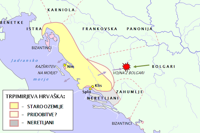
English: Map of duke Trpimir's territory is based on descriptions of Gotschalk for marine borders, on descriptions in De administando imperio (DAE) for Croatia in X.th century AD with Livno district, and descriptions of war with Bulgarians. For Gotschalk: look in Klaić Nada (1990): Povijest Hrvata u srednjem vijeku. Zagreb, Globus, Page 58-59. For DAE: look in Goldstein Ivo (2008): Hrvaška zgodovina. Ljubljana, Društvo Slovenska matica. Page 36; Klaić Nada (1990): Povijest Hrvata u srednjem vijeku. Zagreb, Globus, Page 76-77; Šišić Ferdo (1990): Povijest Hrvata u vrijeme narodnih vladara. Zagreb, Nakladni zavod Matice hrvatske. Page 446.For the war with Bulgarians: look in Klaić Nada (1990): Povijest Hrvata u srednjem vijeku. Zagreb, Globus, Page 59; Voje Ignacij (1994):Nemirni Balkan. Ljubljana, DZS. Page 49. After two wars with Bulgaruians new districts of Livno, Pesenta and Pliva were added to croatian state. So- the Livno district was probably anexed already in the time of Trpimir. Also compare with Dezela kneza Borne.PNG |
| Date | (UTC) |
| Source | |
| Author |
|
| This is a retouched picture, which means that it has been digitally altered from its original version. Modifications: Map of Trpimir's state. The original can be viewed here: Waterways of SE Central Europe.svg:
|
| I, the copyright holder of this work, release this work into the public domain. This applies worldwide. In some countries this may not be legally possible; if so: I grant anyone the right to use this work for any purpose, without any conditions, unless such conditions are required by law. |
Original upload log[edit]
This image is a derivative work of the following images:
- File:Waterways_of_SE_Central_Europe.svg licensed with PD-self
- 2010-01-08T20:49:27Z Kmiki87 1415x1059 (292577 Bytes) {{Information |Description={{en|1=Waterways along the central and lower Danube, including the Bohemian and Carpathian Basins, the northern Balkans, parts of Austria, southern Poland and Western Ukraine.}} |Source={{own}} |Aut
Uploaded with derivativeFX
File history
Click on a date/time to view the file as it appeared at that time.
| Date/Time | Thumbnail | Dimensions | User | Comment | |
|---|---|---|---|---|---|
| current | 17:43, 21 June 2010 | | 823 × 547 (82 KB) | Bostjan46 (talk | contribs) | Colors. |
| 17:41, 21 June 2010 |  | 793 × 546 (61 KB) | Bostjan46 (talk | contribs) | Colors. | |
| 16:48, 21 June 2010 |  | 823 × 547 (82 KB) | Bostjan46 (talk | contribs) | {{Information |Description={{en|1=Map of duke Trpimir's territory is based on descriptions of Gotschalk for marine borders, on descriptions in De administando imperio (DAE) for Croatia in X.th century AD with Livno district, and descriptions of war with B |
You cannot overwrite this file.
File usage on Commons
The following page uses this file:
File usage on other wikis
The following other wikis use this file:
- Usage on de.wikipedia.org
- Usage on sh.wikipedia.org
- Usage on sl.wikipedia.org