File:Tropical Storm Sanba (MODIS).jpg
Jump to navigation
Jump to search

Size of this preview: 731 × 600 pixels. Other resolutions: 293 × 240 pixels | 585 × 480 pixels | 936 × 768 pixels | 1,249 × 1,024 pixels | 2,497 × 2,048 pixels | 7,320 × 6,004 pixels.
Original file (7,320 × 6,004 pixels, file size: 3.98 MB, MIME type: image/jpeg)
Captions
Captions
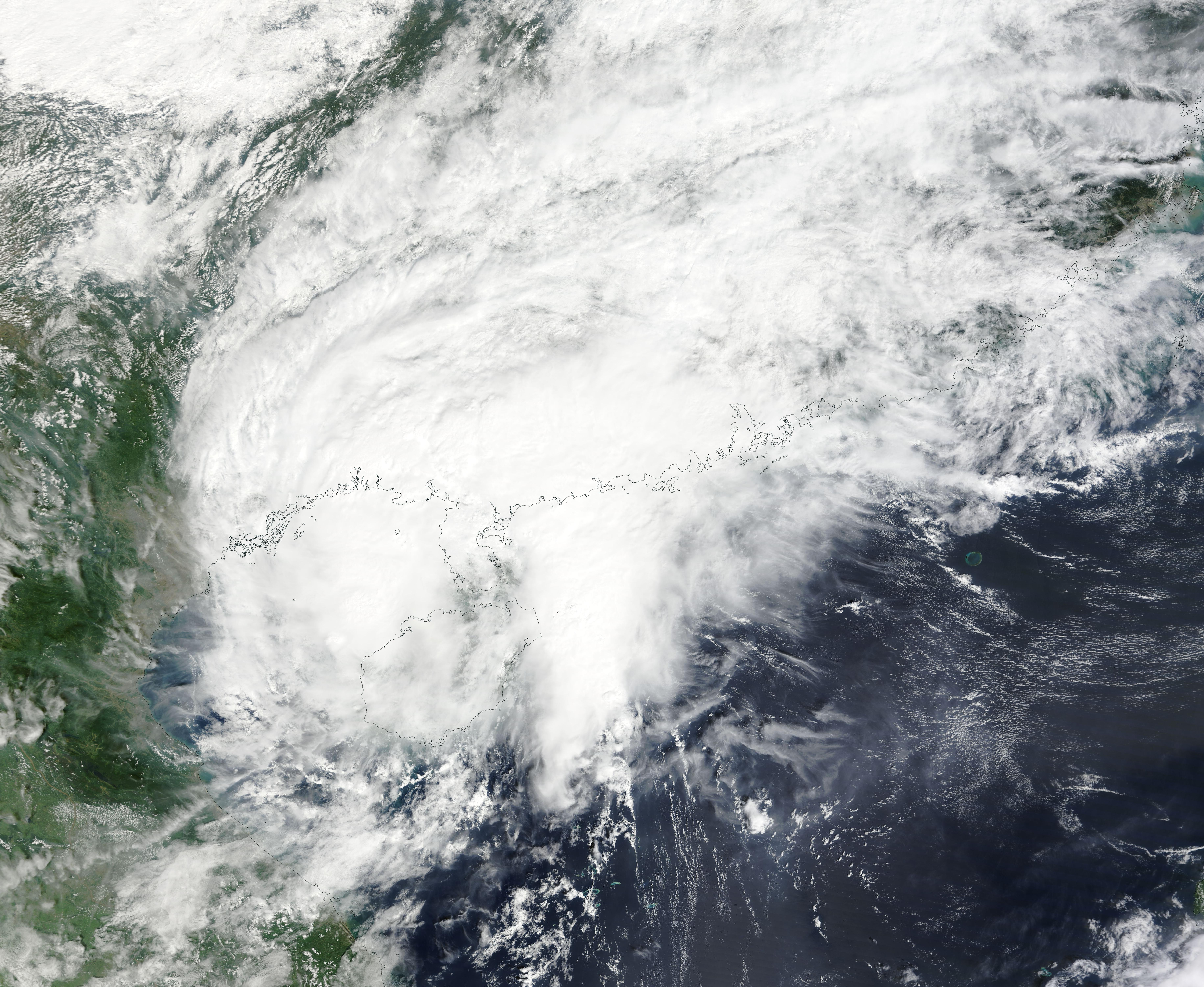
After passing close to the west coast of Taiwan, Tropical Storm Sanba was making landfall on the island of province of Hainan, China on October 19, 2023, when the Moderate Resolution Imaging Spectroradiometer (MODIS) acquired this true-color image.
Summary
[edit].jpg&action=edit§ion=1)
| Description |
English: After passing close to the west coast of Taiwan, Tropical Storm Sanba was making landfall on the island of province of Hainan, China on October 19, 2023, when the Moderate Resolution Imaging Spectroradiometer (MODIS) acquired this true-color image. It was carrying maximum sustained winds of about 45 mph (72.5 km/h) and was bringing rain, gusty winds, and storm surge to parts of China, Taiwan, and Vietnam.
After landfall, the storm oscillated in the Gulf of Tonkin, according to Colorado State University’s Cooperative Institute for Research in the Atmosphere (CIRA). By 11:00 p.m. EDT on October 19 (0300 UTC on October 20) the Joint Typhoon Warning Center (JWTC) advised that Sanba was located about 227 miles (365 km) east of Hanoi, Vietnam and carrying maximum sustained winds of about 29 mph (46.7 km/h). The JTWC advisory also stated, “visible imagery depicts an increasingly chaotic scene over the past six hours as Tropical Storm Sanba came ashore and stretched out with the upper-level circulation moving northeastward, while the low-level circulation (LLCC) stalled”. The forecast calls for a southerly or southwesterly turn of the remnant of the low-level circulation, resulting in dissipation of the remnants of Tropical Storm Sanba over the Gulf of Tonkin within 24 hours. |
||
| Date | Taken on 19 October 2023 | ||
| Source |
Tropical Storm Sanba (direct link)
|
||
| Author | MODIS Land Rapid Response Team, NASA GSFC |
| This media is a product of the Terra mission Credit and attribution belongs to the mission team, if not already specified in the "author" row |
Licensing
[edit].jpg&action=edit§ion=2)
| This file is in the public domain in the United States because it was solely created by NASA. NASA copyright policy states that "NASA material is not protected by copyright unless noted". (See Template:PD-USGov, NASA copyright policy page or JPL Image Use Policy.) | ||
 |
Warnings:
|
File history
Click on a date/time to view the file as it appeared at that time.
| Date/Time | Thumbnail | Dimensions | User | Comment | |
|---|---|---|---|---|---|
| current | 05:05, 20 October 2023 | | 7,320 × 6,004 (3.98 MB) | OptimusPrimeBot (talk | contribs) | #Spacemedia - Upload of http://modis.gsfc.nasa.gov/gallery/images/image10202023_250m.jpg via Commons:Spacemedia |
You cannot overwrite this file.
File usage on Commons
There are no pages that use this file.
.jpg&oldid=813567876)