File:Trizonia.png
Jump to navigation
Jump to search
No higher resolution available.
Trizonia.png (464 × 599 pixels, file size: 51 KB, MIME type: image/png)
Captions
Captions
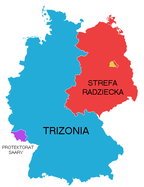
This image shows the 3 countries - USA, France, and UK combined to create Trizonia. Berlin, which is located in the soviet occupied zone of germany, is also divided into west berlin (Trizonia) and east berlin (the USSR.)
| Description |
English: This image shows the 3 countries - USA, France, and UK combined to create Trizonia. Berlin, which is located in the soviet occupied zone of germany, is also divided into west berlin (Trizonia) and east berlin (the USSR.) |
||
| Date | |||
| Source | Own work based on Atlas historyczny dla liceum, wyd. PWN. | ||
| Author | Mix321 | ||
| Permission (Reusing this file) |
|

File history
Click on a date/time to view the file as it appeared at that time.
| Date/Time | Thumbnail | Dimensions | User | Comment | |
|---|---|---|---|---|---|
| current | 17:50, 18 December 2009 | | 464 × 599 (51 KB) | Mix321 (talk | contribs) | {{Information |Description={{en|1=en:Trizone pl:Trizonia}} |Source={{own}} |Author=Mix321 |Date=2009.XII.18 |Permission={{GFDL|self}} |other_versions= }} Category:Trizone Category:Maps of the history of Germany |
You cannot overwrite this file.
File usage on Commons
There are no pages that use this file.
File usage on other wikis
The following other wikis use this file: