File:Tripoint Trail CA NV OR Topo Map.jpg
Jump to navigation
Jump to search
Size of this preview: 800 × 514 pixels. Other resolutions: 320 × 206 pixels | 640 × 411 pixels | 1,024 × 658 pixels.
Original file (1,024 × 658 pixels, file size: 289 KB, MIME type: image/jpeg)
Captions
Captions
Add a one-line explanation of what this file represents
Summary
[edit]
| Description |
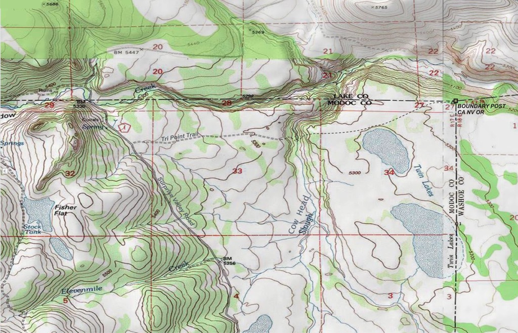
English: Topo Map of area of the California Nevada Oregon Boundary Monument established in the 1872 Von Schmidt survey. Shows trail to the tripoint ( tri-point, or tri point) and USGS or NGS Benchmark marker. This historic boundary marker is the corner of the legal boundary, as decided in the US Supreme Court. Described in the Decree of the Supreme Court, in California v. Nevada, case 456 U.S. 867 (1982). Decided June 10, 1980.
"That the location of the boundary between the States of California and Nevada is as hereafter specified: " "Beginning at the Initial Point on the California-Nevada boundary as established under authority of the Act of June 10, 1872, 17 Stat. 358, by Allexey W. Von Schmidt in 1872 as an eight (8) inch square wood post set in a large mound of stone at the intersection to the 42nd parallel of north latitude along the southern boundary of the State of Oregon and the 120th degree of longitude west from Greenwich, each as reported by him; thence running southerly along said 1872 boundary as surveyed and marked by Allexey W. Von Schmidt to a cast iron monument designated as Von Schmidt Milepost 191 on said boundary..." |
| Date | |
| Source | US Geological Survey (USGS), Department of the Interior, US Government. National Geodetic Survey (NGS). Released to public domain. |
| Author | US Geological Survey. National Geodetic Survey. |
| Camera location | | View this and other nearby images on: OpenStreetMap |
|---|
Licensing
[edit]
This work is in the public domain in the United States because it is a work prepared by an officer or employee of the United States Government as part of that person’s official duties under the terms of Title 17, Chapter 1, Section 105 of the US Code.
Note: This only applies to original works of the Federal Government and not to the work of any individual U.S. state, territory, commonwealth, county, municipality, or any other subdivision. This template also does not apply to postage stamp designs published by the United States Postal Service since 1978. (See § 313.6(C)(1) of Compendium of U.S. Copyright Office Practices). It also does not apply to certain US coins; see The US Mint Terms of Use.
|
 | |
| This file has been identified as being free of known restrictions under copyright law, including all related and neighboring rights. | ||
File history
Click on a date/time to view the file as it appeared at that time.
| Date/Time | Thumbnail | Dimensions | User | Comment | |
|---|---|---|---|---|---|
| current | 11:00, 24 September 2014 | | 1,024 × 658 (289 KB) | Expeditionradio (talk | contribs) | User created page with UploadWizard |
You cannot overwrite this file.
File usage on Commons
The following page uses this file:
File usage on other wikis
The following other wikis use this file:
- Usage on ky.wikipedia.org