File:Tribal Map MN.svg
Jump to navigation
Jump to search

Size of this PNG preview of this SVG file: 463 × 599 pixels. Other resolutions: 185 × 240 pixels | 371 × 480 pixels | 593 × 768 pixels | 791 × 1,024 pixels | 1,582 × 2,048 pixels | 816 × 1,056 pixels.
Original file (SVG file, nominally 816 × 1,056 pixels, file size: 3.59 MB)
Captions
Captions
Add a one-line explanation of what this file represents
Summary
[edit]
| Description |
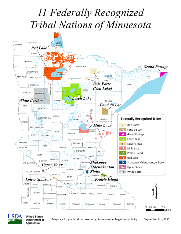
English: A map depicting the 11 Indian reservations in the U.S. state of Minnesota. |
| Date | |
| Source | https://www.nrcs.usda.gov/wps/wcm/connect/679fcff2-f2e8-427a-84b2-49cc1819731d/Tribal_Map_MN.pdf?MOD=AJPERES&CVID=njvW2ms |
| Author | United States Department of Agriculture |
Licensing
[edit]
This image or file is a work of a United States Department of Agriculture employee, taken or made as part of that person's official duties. As a work of the U.S. federal government, the image is in the public domain.
|
 |
File history
Click on a date/time to view the file as it appeared at that time.
| Date/Time | Thumbnail | Dimensions | User | Comment | |
|---|---|---|---|---|---|
| current | 23:48, 2 June 2024 | | 816 × 1,056 (3.59 MB) | Jan-Janko (talk | contribs) | The original file had a transparent border. I changed it to white. |
| 13:58, 14 May 2024 |  | 816 × 1,056 (2.71 MB) | Jan-Janko (talk | contribs) | Uploaded a work by United States Department of Agriculture from https://www.nrcs.usda.gov/wps/wcm/connect/679fcff2-f2e8-427a-84b2-49cc1819731d/Tribal_Map_MN.pdf?MOD=AJPERES&CVID=njvW2ms with UploadWizard |
You cannot overwrite this file.
File usage on Commons
The following page uses this file:
File usage on other wikis
The following other wikis use this file:
- Usage on en.wikipedia.org