File:Tramway Paris T2-plan.svg
Jump to navigation
Jump to search

Size of this PNG preview of this SVG file: 800 × 110 pixels. Other resolutions: 320 × 44 pixels | 640 × 88 pixels | 1,024 × 141 pixels | 1,280 × 176 pixels | 2,560 × 352 pixels | 2,599 × 357 pixels.
Original file (SVG file, nominally 2,599 × 357 pixels, file size: 108 KB)
Captions
Captions
Add a one-line explanation of what this file represents
Summary
[edit]
| Description |
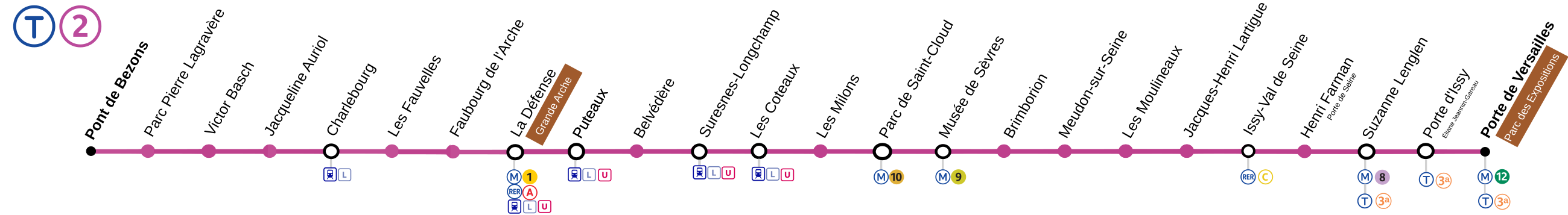
English: Map of the tramway paris line 2
Français : Plan de la ligne de métro numéro 2 du tramway de Paris |
| Date | |
| Source | Own work based on RATP file [1] with the Image:Logo Train.svg image. |
| Author | Hektor |
![[1]](http://www.ratp.info/picts/plans/gif/reseaux/t2.gif)
This W3C-unspecified vector image was created with Inkscape .
Licensing
[edit]
I, the copyright holder of this work, hereby publish it under the following licenses:

|
Permission is granted to copy, distribute and/or modify this document under the terms of the GNU Free Documentation License, Version 1.2 or any later version published by the Free Software Foundation; with no Invariant Sections, no Front-Cover Texts, and no Back-Cover Texts. A copy of the license is included in the section entitled GNU Free Documentation License. |
This file is licensed under the Creative Commons Attribution-Share Alike 3.0 Unported, 2.5 Generic, 2.0 Generic and 1.0 Generic license.
- You are free:
- to share – to copy, distribute and transmit the work
- to remix – to adapt the work
- Under the following conditions:
- attribution – You must give appropriate credit, provide a link to the license, and indicate if changes were made. You may do so in any reasonable manner, but not in any way that suggests the licensor endorses you or your use.
- share alike – If you remix, transform, or build upon the material, you must distribute your contributions under the same or compatible license as the original.
You may select the license of your choice.
File history
Click on a date/time to view the file as it appeared at that time.
| Date/Time | Thumbnail | Dimensions | User | Comment | |
|---|---|---|---|---|---|
| current | 10:39, 23 October 2019 | 2,599 × 357 (108 KB) | AlexBurn44 (talk | contribs) | ++ | |
| 22:23, 12 October 2018 | 2,599 × 357 (106 KB) | AlexBurn44 (talk | contribs) | Logo transillien | ||
| 11:52, 3 September 2016 | 2,599 × 357 (127 KB) | The BurnPheonix (talk | contribs) | correspondances | ||
| 12:46, 12 December 2012 | 2,599 × 357 (98 KB) | P.poschadel (talk | contribs) | Update : line T3 -> line T3a. | ||
| 11:42, 18 November 2012 | 2,599 × 357 (100 KB) | Hektor (talk | contribs) | Extension of the T2 line - December 18 2012 | ||
| 23:59, 21 November 2009 | 2,010 × 380 (304 KB) | Gonioul (talk | contribs) | extention opened | ||
| 23:49, 16 November 2009 | 2,010 × 380 (305 KB) | Gonioul (talk | contribs) | +M8 at Suzanne like official plans | ||
| 22:06, 5 October 2009 | 2,010 × 380 (301 KB) | Gonioul (talk | contribs) | forgot line 12... | ||
| 21:59, 5 October 2009 | 2,010 × 380 (299 KB) | Gonioul (talk | contribs) | preparing south-east extention for the end of november | ||
| 12:55, 21 August 2008 | 1,598 × 380 (76 KB) | Hektor (talk | contribs) |
You cannot overwrite this file.
File usage on Commons
The following 11 pages use this file:
- User:Chumwa/OgreBot/Potential transport maps/2016 September 1-10
- User:Chumwa/OgreBot/Potential transport maps/2018 October 11-20
- User:Chumwa/OgreBot/Potential transport maps/2019 October 21-31
- User:Chumwa/OgreBot/Public transport information/2016 September 1-10
- User:Chumwa/OgreBot/Public transport information/2018 October 11-20
- User:Chumwa/OgreBot/Public transport information/2019 October 21-31
- User:Chumwa/OgreBot/Transport Maps/2016 September 1-10
- User:Chumwa/OgreBot/Transport Maps/2018 October 11-20
- User:Chumwa/OgreBot/Transport Maps/2019 October 21-31
- User:Chumwa/OgreBot/Travel and communication maps/2016 September 1-10
- User:Chumwa/OgreBot/Travel and communication maps/2018 October 11-20
File usage on other wikis
The following other wikis use this file:
- Usage on cs.wikipedia.org
- Usage on de.wikipedia.org
- Usage on eo.wikipedia.org
- Usage on fr.wikipedia.org
- Usage on pt.wikipedia.org