File:Trails of Cascade Range map-fr.svg
Jump to navigation
Jump to search

Size of this PNG preview of this SVG file: 348 × 598 pixels. Other resolutions: 139 × 240 pixels | 279 × 480 pixels | 446 × 768 pixels | 595 × 1,024 pixels | 1,191 × 2,048 pixels | 403 × 693 pixels.
Original file (SVG file, nominally 403 × 693 pixels, file size: 3.3 MB)
Captions
Captions
Add a one-line explanation of what this file represents
Summary[edit]
| Description |
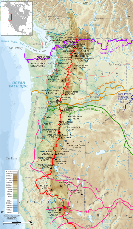
Français : Carte topographique de la Chaîne des Cascades montrant divers chemins de grande randonnée. English: Map of Cascade Range showing some trails. |
| Date | (28 mars 2010) |
| Source |
Own work from File:Cascade Range topographic map-fr.svg by User:Bourrichon +
|
| Author | Bourrichon |
Licensing[edit]
I, the copyright holder of this work, hereby publish it under the following licenses:

|
Permission is granted to copy, distribute and/or modify this document under the terms of the GNU Free Documentation License, Version 1.2 or any later version published by the Free Software Foundation; with no Invariant Sections, no Front-Cover Texts, and no Back-Cover Texts. A copy of the license is included in the section entitled GNU Free Documentation License. |
This file is licensed under the Creative Commons Attribution-Share Alike 3.0 Unported, 2.5 Generic, 2.0 Generic and 1.0 Generic license.
- You are free:
- to share – to copy, distribute and transmit the work
- to remix – to adapt the work
- Under the following conditions:
- attribution – You must give appropriate credit, provide a link to the license, and indicate if changes were made. You may do so in any reasonable manner, but not in any way that suggests the licensor endorses you or your use.
- share alike – If you remix, transform, or build upon the material, you must distribute your contributions under the same or compatible license as the original.
You may select the license of your choice.
File history
Click on a date/time to view the file as it appeared at that time.
| Date/Time | Thumbnail | Dimensions | User | Comment | |
|---|---|---|---|---|---|
| current | 13:46, 19 April 2010 | | 403 × 693 (3.3 MB) | Bourrichon (talk | contribs) | allègement |
| 18:18, 2 April 2010 |  | 403 × 693 (15.24 MB) | Bourrichon (talk | contribs) | + | |
| 18:11, 2 April 2010 |  | 403 × 693 (15.21 MB) | Bourrichon (talk | contribs) | +other trails (cf source) | |
| 16:24, 28 March 2010 |  | 403 × 693 (10.38 MB) | Bourrichon (talk | contribs) | {{Information |Description={{fr|Carte topographique de la fr:Chaîne des Cascades montrant divers chemins de grande randonnée.}}{{en|Map of en:Cascade Range showing some trails.}} |Source={{own}} from [[:File:Cascade Range topographic map-fr. |
You cannot overwrite this file.
File usage on Commons
The following 8 pages use this file:
- File:Cascade Range blank map protected areas map-fr.svg
- File:Cascade Range major volcanoes topographic map-fr.png
- File:Cascade Range major volcanoes topographic map-fr.svg
- File:Cascade Range map protected areas map-fr.svg
- File:Cascade Range protected areas map-fr.svg
- File:Cascade Range topographic blank map.png
- File:Cascade Range topographic map-fr.svg
- Template:Other versions/Cascade Range map
File usage on other wikis
The following other wikis use this file:
- Usage on es.wikipedia.org
- Usage on fr.wikipedia.org
- Usage on it.wikipedia.org
- Usage on vi.wikipedia.org