File:Touring Fort Moultrie LOC 2002625046.jpg
Jump to navigation
Jump to search

Size of this preview: 800 × 379 pixels. Other resolutions: 320 × 152 pixels | 640 × 303 pixels | 1,024 × 485 pixels | 1,280 × 606 pixels | 2,560 × 1,213 pixels | 10,115 × 4,792 pixels.
Original file (10,115 × 4,792 pixels, file size: 7.73 MB, MIME type: image/jpeg)
Captions
Captions
Add a one-line explanation of what this file represents
Summary
[edit]| Description |
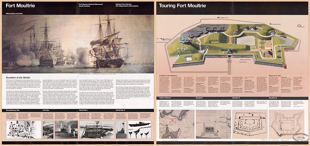
English: Bird's-eye view. "*GPO: 2001--472-470/40097. Reprint 2001." Includes descriptive index, text, ancillary map of Charleston Harbor, and 3 ancillary maps of Fort Moultrie. Text and ill. (some col.) on verso. Available also through the Library of Congress Web site as a raster image. |
||
| Title | Touring Fort Moultrie | ||
| Shelf ID | G3914.C3:2F5A3 2001 .U5 | ||
| Date | |||
| Source | https://www.loc.gov/item/2002625046/ | ||
| Author | United States. National Park Service | ||
| Permission (Reusing this file) |
|
||
| Other versions |
|
||
| Location | South Carolina · Charleston · Fort Sumter National Monument · United States · Fort Moultrie | ||
| Part of | American Memory · Cities And Towns · Catalog · Geography And Map Division | ||
| Subject | Aerial Views · Fort Moultrie (S.C.) · Fort Sumter National Monument · United States · Maps · Fort Sumter National Monument (Charleston, S.C.) · Fort Moultrie · South Carolina · Charleston |

Licensing
[edit]
| This image or media file contains material based on a work of a National Park Service employee, created as part of that person's official duties. As a work of the U.S. federal government, such work is in the public domain in the United States. See the NPS website and NPS copyright policy for more information. |
File history
Click on a date/time to view the file as it appeared at that time.
| Date/Time | Thumbnail | Dimensions | User | Comment | |
|---|---|---|---|---|---|
| current | 12:30, 20 September 2018 | | 10,115 × 4,792 (7.73 MB) | Fæ (talk | contribs) | LOC Maps https://www.loc.gov/item/2002625046/ #34638 |
You cannot overwrite this file.
File usage on Commons
The following page uses this file: