File:Toronto, Ontario street circuit track map.svg
Jump to navigation
Jump to search

Size of this PNG preview of this SVG file: 800 × 552 pixels. Other resolutions: 320 × 221 pixels | 640 × 441 pixels | 1,024 × 706 pixels | 1,280 × 883 pixels | 2,560 × 1,766 pixels | 1,428 × 985 pixels.
Original file (SVG file, nominally 1,428 × 985 pixels, file size: 111 KB)
Captions
Captions
Add a one-line explanation of what this file represents
Summary[edit]
| Description |
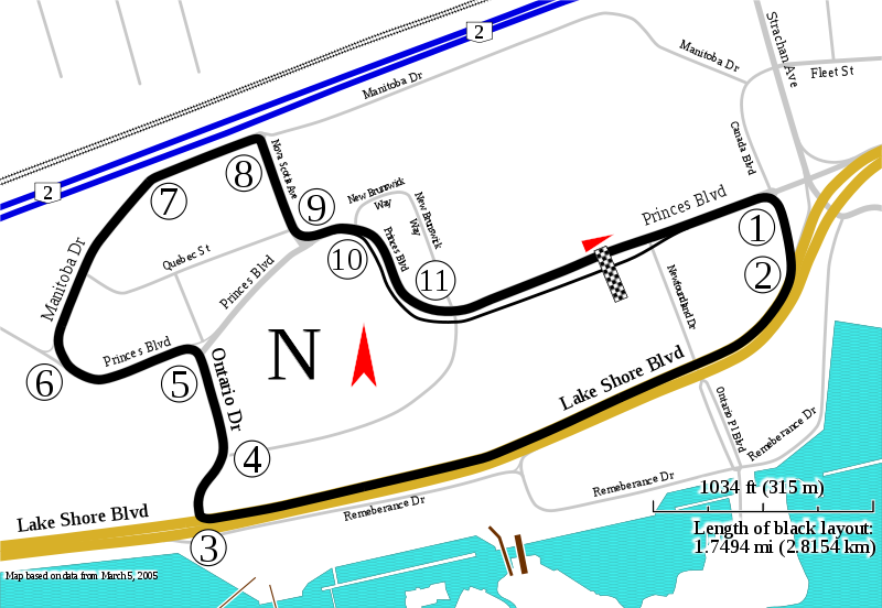
English: Track map for use with Honda Indy Toronto before 2016 pit lane change[1] showing the streets, track length, turn numbers, and more. |
| Date | |
| Source | Own work |
| Author | Will Pittenger |
| Other versions |
|

This W3C-unspecified vector image was created with Inkscape .
| Camera location | | View this and other nearby images on: OpenStreetMap |
|---|
Licensing[edit]
I, the copyright holder of this work, hereby publish it under the following license:
This file is licensed under the Creative Commons Attribution-Share Alike 3.0 Unported license.
- You are free:
- to share – to copy, distribute and transmit the work
- to remix – to adapt the work
- Under the following conditions:
- attribution – You must give appropriate credit, provide a link to the license, and indicate if changes were made. You may do so in any reasonable manner, but not in any way that suggests the licensor endorses you or your use.
- share alike – If you remix, transform, or build upon the material, you must distribute your contributions under the same or compatible license as the original.
File history
Click on a date/time to view the file as it appeared at that time.
| Date/Time | Thumbnail | Dimensions | User | Comment | |
|---|---|---|---|---|---|
| current | 12:06, 13 November 2009 | | 1,428 × 985 (111 KB) | Will Pittenger (talk | contribs) | Made railroad tracks larger and easier to see while reducing their node count |
| 12:01, 13 November 2009 |  | 1,428 × 985 (120 KB) | Will Pittenger (talk | contribs) | Changed fill of water to show waves and fixed some clipping issues. | |
| 11:37, 13 November 2009 |  | 1,428 × 985 (116 KB) | Will Pittenger (talk | contribs) | {{Information |Description={{en|1=Track map for use with w:Honda Indy Toronto showing the streets, track length, turn numbers, and more.}} |Source={{own}} |Author=Will Pittenger |Date=2009-11-13 |Permission= |other_versions=<g |
You cannot overwrite this file.
File usage on Commons
The following 2 pages use this file:
File usage on other wikis
The following other wikis use this file:
- Usage on ar.wikipedia.org
- Usage on de.wikipedia.org
- Usage on en.wikipedia.org
- Exhibition Place
- Flag to Flag
- 2006 Molson Grand Prix of Toronto
- List of Champ Car circuits
- 2007 Steelback Grand Prix
- 2005 Molson Indy Toronto
- Canadian Touring Car Championship
- 2004 Molson Indy Toronto
- 2003 Molson Indy Toronto
- User:Falcadore/sandbox1
- 2009 Honda Indy Toronto
- 2002 Molson Indy Toronto
- 1999 Molson Indy Toronto
- List of IndyCar Series racetracks
- 2001 Molson Indy Toronto
- 2010 Honda Indy Toronto
- 1998 Molson Indy Toronto
- 2011 Honda Indy Toronto
- List of auto racing tracks in Canada
- 2012 Honda Indy Toronto
- List of GT World Challenge America circuits
- 2013 Honda Indy Toronto
- 2014 Honda Indy Toronto
- User:TorontoGuy79/sandbox
- 2015 Honda Indy Toronto
- Usage on es.wikipedia.org
- Temporada 2011 de IndyCar Series
- Portal:Automovilismo/Carrera/Lista
- Portal:Automovilismo/Carrera/Gran Premio de Toronto
- Anexo:Circuitos de campeonatos de monoplazas de Estados Unidos
- Temporada 2014 de Indy Lights
- Portal:IndyCar/Circuito/Lista
- Temporada 2015 de IndyCar Series
- Temporada 2016 de IndyCar Series
- Usage on fa.wikipedia.org
- Usage on fr.wikipedia.org
- Usage on hu.wikipedia.org
View more global usage of this file.