File:Topographie de toulouse.jpg
Jump to navigation
Jump to search

Size of this preview: 600 × 600 pixels. Other resolutions: 240 × 240 pixels | 480 × 480 pixels | 768 × 768 pixels | 1,024 × 1,024 pixels | 1,280 × 1,280 pixels.
Original file (1,280 × 1,280 pixels, file size: 571 KB, MIME type: image/jpeg)
Captions
Captions
Add a one-line explanation of what this file represents
Summary[edit]
| Description |
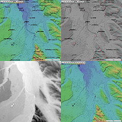
Français : Topographie de Toulouse
4 images topographiques (20 km de côté) de Toulouse, prises par la mission SRTM.
|
| Source | NASA |
| Author | NASA |
Licensing[edit]
| This file is in the public domain in the United States because it was solely created by NASA. NASA copyright policy states that "NASA material is not protected by copyright unless noted". (See Template:PD-USGov, NASA copyright policy page or JPL Image Use Policy.) | ||
 |
Warnings:
|
Original upload log[edit]
The original description page was here. All following user names refer to fr.wikipedia.
- 2004-11-17 22:46 NaSH 1280×1280× (584800 bytes) Topographie de Toulouse
File history
Click on a date/time to view the file as it appeared at that time.
| Date/Time | Thumbnail | Dimensions | User | Comment | |
|---|---|---|---|---|---|
| current | 15:24, 15 October 2009 | | 1,280 × 1,280 (571 KB) | Korribot (talk | contribs) | {{BotMoveToCommons|fr.wikipedia|year={{subst:CURRENTYEAR}}|month={{subst:CURRENTMONTHNAME}}|day={{subst:CURRENTDAY}}}} {{Information |Description={{fr|fr:Catégorie:Image de Toulouse Topographie de fr:Toulouse 4 images topographiques (20 km |
You cannot overwrite this file.
File usage on Commons
The following page uses this file:
File usage on other wikis
The following other wikis use this file: