File:Topographical Map of All Lands Situated in Santa Clara Co. Belonging to Leland Stanford Jr University.jpg

Original file (11,428 × 9,028 pixels, file size: 7.14 MB, MIME type: image/jpeg)
Captions
Captions
Summary[edit]
| Warning | The original file is very high-resolution. It might not load properly or could cause your browser to freeze when opened at full size. |
|---|
| Description |
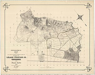
English: Item Number: 1032-122-pt3
Document Title: L.Stanford Jr. Univ./Top. Map with New Searsville Road [v] /Topo/Map of/all Lands situated in Santa Clara Co./ Belonging to/Leland Stanford Jr./ University/ at/ Palo Alto, Cal./ Surveyed at the Request of F.L. Olmsted, L.A./; Scale 500' = 1" [orig] Project: 01032; Stanford, Leland Jr. University; Plans Sent cards only --Leland Stanford Jr., Universiy -- --; Stanford; Palo Alto; California; 04 College & School Campuses; 256 PLANS (1883-1891; 1914; 1930-1931) Location: Olmsted National Historic Site, Brookline, MA Category: PLAN Purpose: none Physical Characteristics: 0000010951 29 1/2" x 26" lith pos water/g --graphite paper Dates: JAN-1888[v] Notes: [The ubiquitous litho, plan with a road colored in brown] Please credit: Courtesy of the United States Department of the Interior, National Park Service, Frederick Law Olmsted National Historic Site. |
| Date | |
| Source | United States Department of the Interior, National Park Service, Frederick Law Olmsted National Historic Site, created 1886–1887 |
| Author | Map by J.G. McMillian, J.G. Gould, Frederick Law Olmsted |
Licensing[edit]
This work is in the public domain in the United States because it was published (or registered with the U.S. Copyright Office) before January 1, 1929.
Public domain works must be out of copyright in both the United States and in the source country of the work in order to be hosted on the Commons. If the work is not a U.S. work, the file must have an additional copyright tag indicating the copyright status in the source country.
Note: This tag should not be used for sound recordings. |
File history
Click on a date/time to view the file as it appeared at that time.
| Date/Time | Thumbnail | Dimensions | User | Comment | |
|---|---|---|---|---|---|
| current | 21:51, 3 April 2021 | | 11,428 × 9,028 (7.14 MB) | Joojay (talk | contribs) | Uploaded a work by Map by J.G. McMillian, J.G. Gould, Frederick Law Olmsted from United States Department of the Interior, National Park Service, Frederick Law Olmsted National Historic Site, created 1886–1887 with UploadWizard |
You cannot overwrite this file.
File usage on Commons
The following page uses this file: