File:Topographic-map-of-Montserrat-de.png
Jump to navigation
Jump to search
Size of this preview: 419 × 600 pixels. Other resolutions: 167 × 240 pixels | 335 × 480 pixels | 536 × 768 pixels | 1,047 × 1,499 pixels.
Original file (1,047 × 1,499 pixels, file size: 496 KB, MIME type: image/png)
Captions
Captions
Add a one-line explanation of what this file represents
Summary[edit]
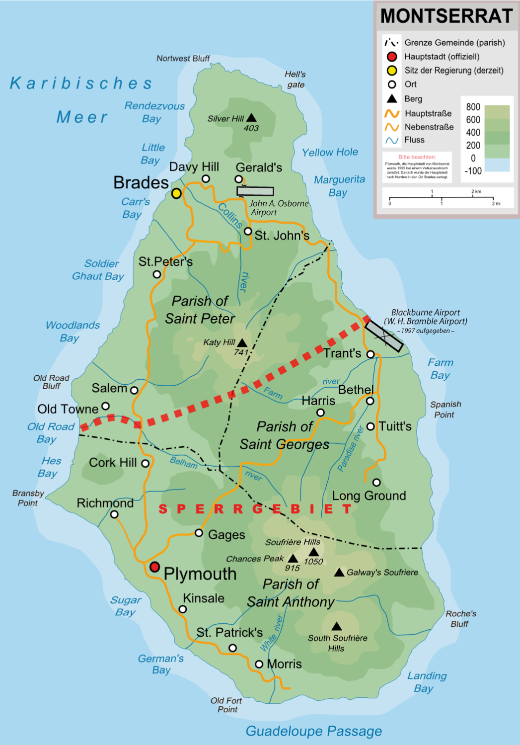
| Description | Topographische Karte von Montserrat in Deutsch |
| Date | |
| Source |
"own work", used: |
| Author | Lencer |
| Other versions |
[]
|


|
This map has been made or improved in the German Kartenwerkstatt (Map Lab). You can propose maps to improve as well.
|
Licensing[edit]
| I, the copyright holder of this work, release this work into the public domain. This applies worldwide. In some countries this may not be legally possible; if so: I grant anyone the right to use this work for any purpose, without any conditions, unless such conditions are required by law. |
File history
Click on a date/time to view the file as it appeared at that time.
| Date/Time | Thumbnail | Dimensions | User | Comment | |
|---|---|---|---|---|---|
| current | 08:39, 12 March 2011 | | 1,047 × 1,499 (496 KB) | Chumwa (talk | contribs) | John A. Osborne Airport hinzugefügt, Blackburne Airport geschlossen |
| 14:15, 29 July 2010 |  | 1,050 × 1,500 (461 KB) | Lencer (talk | contribs) | + soufriere hills, einige erg. | |
| 10:22, 21 July 2010 |  | 1,050 × 1,500 (433 KB) | Lencer (talk | contribs) | {{Information |Description= Topographische Karte von Montserrat in Deutsch |Source="own work", used: * Topographic-map-of-Montserrat-en.svg by User:Ivan25 * [[:File:Parishes of Montserr |
You cannot overwrite this file.
File usage on Commons
The following 10 pages use this file:
- User:Chumwa/Gallery
- User talk:Ivan25
- File:Topographic-map-of-Montserrat-HE.svg
- File:Topographic-map-of-Montserrat-de.png
- File:Topographic-map-of-Montserrat-en.svg
- File:Topographic-map-of-Montserrat-es.svg
- File:Topographic-map-of-Montserrat-it.svg
- File:Topographic-map-of-Montserrat-mk.svg
- File:Topographic-map-of-Montserrat-sr.svg
- Template:Other versions/Topographic map of Montserrat
File usage on other wikis
The following other wikis use this file:
- Usage on als.wikipedia.org
- Usage on de.wikipedia.org
- Usage on de.wikivoyage.org
- Usage on en.wikipedia.org
- Usage on frr.wikipedia.org