File:Tomography atlantic.png
Jump to navigation
Jump to search

Size of this preview: 675 × 600 pixels. Other resolutions: 270 × 240 pixels | 540 × 480 pixels | 864 × 768 pixels | 1,024 × 910 pixels.
Original file (1,024 × 910 pixels, file size: 295 KB, MIME type: image/png)
Captions
Captions
Add a one-line explanation of what this file represents
Summary
[edit]
| Description |
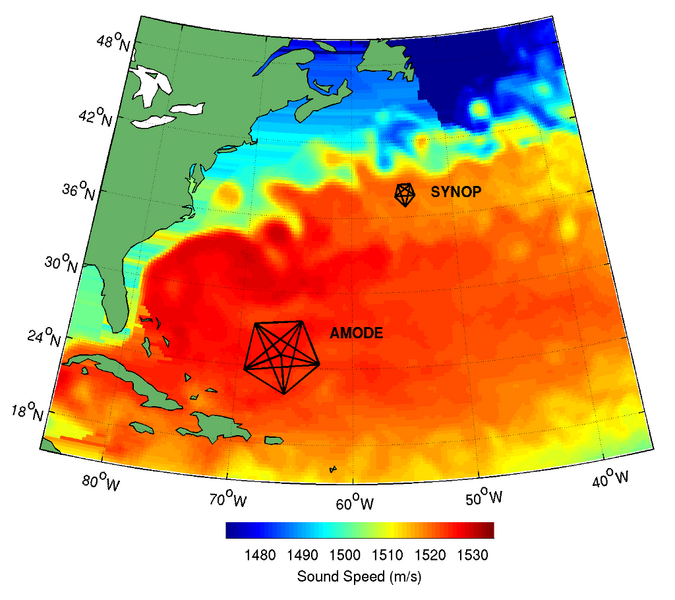
English: The western North Atlantic showing the locations of two experiments employing ocean acoustic tomography. AMODE, the "Acoustic Mid-Ocean Dynamics Experiment" (1991-2), was designed to study ocean dynamics in an area away from the Gulf Stream, and SYNOP (1988-9) was designed to synoptically measure aspects of the Gulf Stream. The colors show a snapshot of sound speed at 300 m depth derived from a high-resolution numerical ocean model. One of the key motivations for employing tomography is that the measurements give averages over the turbulent ocean.
Español: El oeste del Atlántico Norte muestra las ubicaciones de dos experimentos que emplearon la tomografía acústica del océano. AMODE, el "Experimento de Dinámica Medioambiental Acústica" (1990-1), fue diseñado para estudiar la dinámica oceánica en un área alejada de la Corriente del Golfo, y SYNOP (1988-9) fue diseñado para medir sinópticamente aspectos de la Corriente del Golfo. Los colores muestran una instantánea de la velocidad del sonido a 300 m de profundidad derivada de un modelo de océano numérico de alta resolución. Una de las principales motivaciones para emplear la tomografía es que las mediciones dan promedios sobre el océano turbulento. |
| Date | |
| Source | Own work |
| Author | Bdushaw at English Wikipedia |
Licensing
[edit]
| This work has been released into the public domain by its author, Bdushaw at English Wikipedia. This applies worldwide. In some countries this may not be legally possible; if so: Bdushaw grants anyone the right to use this work for any purpose, without any conditions, unless such conditions are required by law. |
Original upload log
[edit]
The original upload log was here. The username refers to the English Wikipedia.
| Date/Time | Dimensions | User | Comment |
|---|---|---|---|
| 00:56, 28 July 2009 | 1,024 × 910 (295 KB) | Bdushaw (talk | contribs | block) | Description = The western North Atlantic showing the locations of two experiments employing ocean acoustic tomography. AMODE, the "Acoustic Mid-Ocean Dynamics Experiment", was designed to study ocean dynamics in an area away from the G |
File history
Click on a date/time to view the file as it appeared at that time.
| Date/Time | Thumbnail | Dimensions | User | Comment | |
|---|---|---|---|---|---|
| current | 15:52, 20 November 2017 | | 1,024 × 910 (295 KB) | De728631 (talk | contribs) | full resolution |
| 15:45, 20 November 2017 |  | 400 × 355 (120 KB) | JuanCallejo (talk | contribs) | User created page with UploadWizard |
You cannot overwrite this file.
File usage on Commons
The following page uses this file:
- File:Tomografía atlántica.png (file redirect)
File usage on other wikis
The following other wikis use this file:
- Usage on en.wikipedia.org
- Usage on es.wikipedia.org
- Usage on mk.wikipedia.org
- Usage on vi.wikipedia.org