File:Toegangsweg tot Tel Aviv met autoverkeer en het gezicht op een spoorwegviaduct en de stadsrand met flatgebouwen. 1 januari 1948.jpg
Jump to navigation
Jump to search
Size of this preview: 798 × 599 pixels. Other resolutions: 320 × 240 pixels | 639 × 480 pixels | 1,022 × 768 pixels | 1,280 × 962 pixels | 2,617 × 1,966 pixels.
Original file (2,617 × 1,966 pixels, file size: 938 KB, MIME type: image/jpeg)
Captions
Captions
Add a one-line explanation of what this file represents
Summary
[edit]| Description |
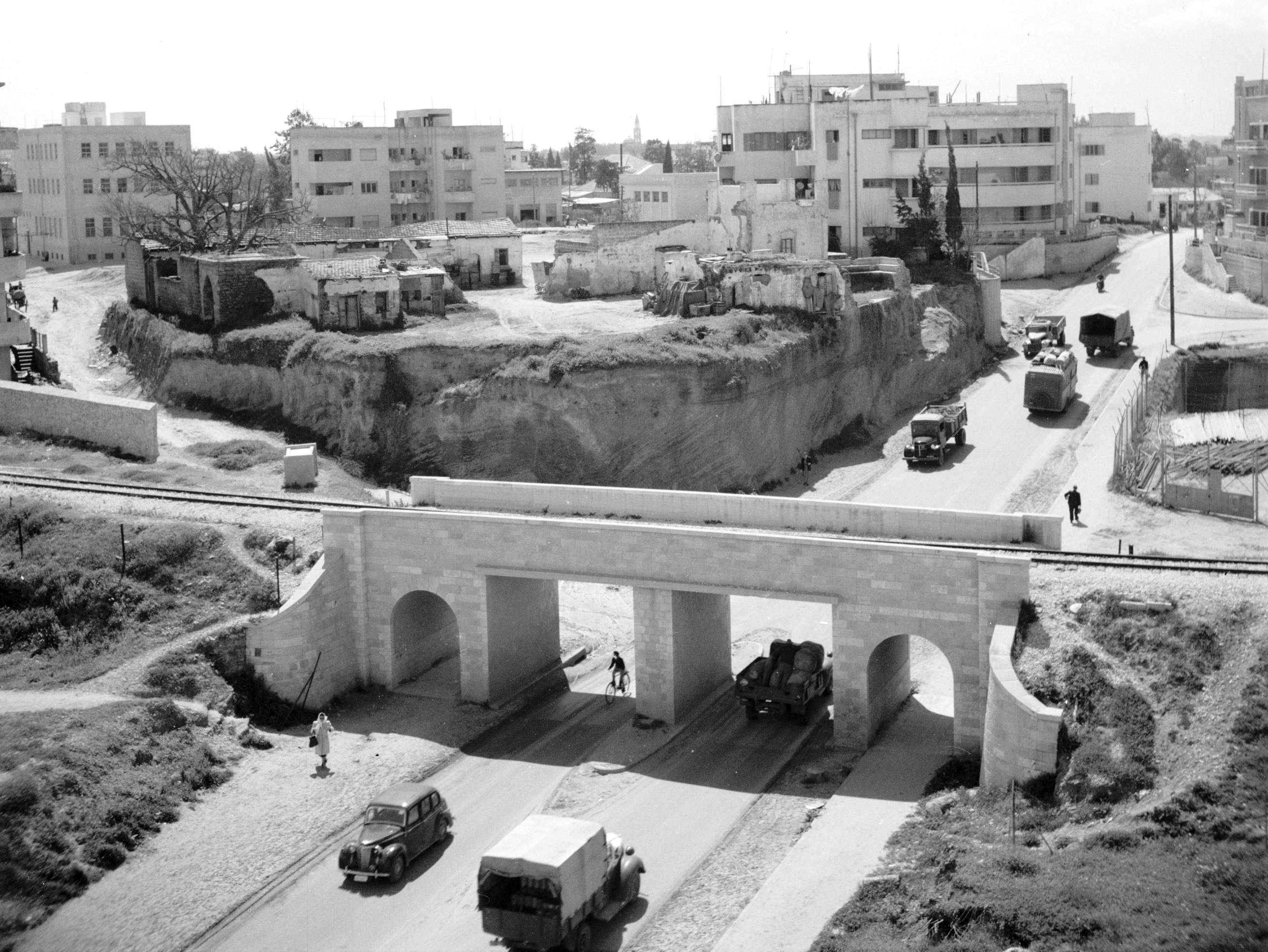
Nederlands: Toegangsweg tot Tel Aviv met autoverkeer en het gezicht op een spoorwegviaduct en de stadsrand met flatgebouwen.
Deutsch: Blick südwestwärts, in der Ferne mit Turm der russ.orth. St. Petrikirche in Abu Kabir, vorn durch den Rechov Rosch Pinnah (רְחוֹב רֹאשׁ פִּנָּה) überspannt vom Gescher Rosch Pinnah (גֶּשֶׁר רֹאשׁ פִּנָּה; Plene: גשר ראש פינה). Der Gescher Rosch Pinnah war eine Brücke der Bahnstrecke Jaffa–Jerusalem (J&J-Linie), die in disem Abschnitt in einer weiten Kurve zwischen ihrem Verlauf in Nordwest-Südost-Richtung parallel zum Rechov ha-Rakkevet und demjenigen in Nord-Süd-Richtung parallel zum Rechov he-Charasch (רְחוֹב הֶחָרָשׁ) wechselte. Der Rechov Rosh Pinnah ist eine Hauptstraße im Ortsteil Naweh Scha'anan (נָוֶה שַׁאֲנָן), die in Südwest-Nordost-Richtung verläuft. Im Bild ist der Blick 1948 nach Südwest gerichtet. In der Ferne erscheint die schlanke Silhouette des Turms der russ.-orth. St. Peterskirche im Ortsteil abu Kabir. Die Bahnstrecke wurde in diesem Abschnitt 1970 stillgelegt und die Brücke 1971 abgebrochen, der Bahndamm abgetragen, die so gewonnene Fläche später in die verbreiterten Straßen Rechov ha-Rakkevet und Rechov he-Charasch (der zugleich die Fernstraße Kvisch 2 bildet) einbezogen. Die Brücke lag im heute weiten Raum der Kreuzung von Rechov ha-Rakkevet (von Nordwest), Rechov ha-Masger (von Nord), Rechov La Guardia (von Ost), Rechov he-Charasch (von Süd), Rechov Levandah (von Süd-Südwest) und Rechov Rosch Pinnah (von Südwest).
English: The Gesher Rosh Pinnah (גֶּשֶׁר רֹאשׁ פִּנָּה) was a bridge by means of which the Jaffa–Jerusalem Railway (J&J line) crossed the Reḥov Rosh Pinnah (רְחוֹב רֹאשׁ פִּנָּה). The bridge lay in a wide curve of the J&J line, by which the railway line changed between its northwest-southeast course parallel to Reḥov ha-Rakkevet and its north-south course parallel to Reḥov he-Kharash (רְחוֹב הֶחָרָשׁ). The Reḥov Rosh Pinnah is a main street in the district of Naveh Sha'anan (נָוֶה שַׁאֲנָן), which runs in the southwest-northeast direction. In this photo from 1948 the view is directed southwestwards into Reḥov Rosh Pinnah, towered in a far distance by the spire of the Russian Orthodox St. Peter Church in the locality of Abu Kabir. The railway line was shut down in this section in 1970 and the bridge demolished in 1971, the railway causeway was removed, the area thus gained was later converted into the widened streets Reḥov ha-Rakkevet and Reḥov he-Kharash (which forms also the trunk road Kvish 2). The bridge lay in what is now the wide area of the intersection of Reḥov ha-Rakkevet (from the north-west), Reḥov ha-Masger (from the north), Reḥov La Guardia (from the east), Reḥov he-Kharash (from the south), Reḥov Levandah (from the south-southwest) and Reḥov Rosh Pinnah (from the south-west). |
||
| Date | |||
| Source |
[1], Nummer toegang 2.24.14.02 Bestanddeelnummer 255-1264
|
||
| Author | Poll, Willem van de | ||
| Other versions |

Licensing
[edit]
This file is licensed under the Creative Commons Attribution-Share Alike 3.0 Unported license.
- You are free:
- to share – to copy, distribute and transmit the work
- to remix – to adapt the work
- Under the following conditions:
- attribution – You must give appropriate credit, provide a link to the license, and indicate if changes were made. You may do so in any reasonable manner, but not in any way that suggests the licensor endorses you or your use.
- share alike – If you remix, transform, or build upon the material, you must distribute your contributions under the same or compatible license as the original.
This file, which was originally posted to
http://proxy.handle.net/10648/aed5dc8c-d0b4-102d-bcf8-003048976d84, was reviewed on 21 December 2014 by reviewer Wdwd, who confirmed that it was available there under the stated license on that date.
|
Category:Photographs by Willem van de Poll in Tel Aviv, Israel (1948)
File history
Click on a date/time to view the file as it appeared at that time.
| Date/Time | Thumbnail | Dimensions | User | Comment | |
|---|---|---|---|---|---|
| current | 20:04, 25 June 2016 | | 2,617 × 1,966 (938 KB) | Geagea (talk | contribs) | crop. |
| 20:02, 25 June 2016 |  | 2,617 × 2,625 (745 KB) | Geagea (talk | contribs) | http://images.memorix.nl/naa/thumb/10000x10000/a7152c43-dea3-4ec9-ba9b-00e710f92aca.jpg | |
| 02:10, 1 August 2014 |  | 1,276 × 1,280 (204 KB) | Geagea (talk | contribs) | =={{int:filedesc}}== {{Information |description={{nl|1=Toegangsweg tot Tel Aviv met autoverkeer en het gezicht op een spoorwegviaduct en de stadsrand met flatgebouwen.}} |date=1948-01-01 |Source=[http://proxy.handle.net/10648/aed5dc8c-d0b4-102d-bcf8-00... |
You cannot overwrite this file.
File usage on Commons
The following 3 pages use this file:
File usage on other wikis
The following other wikis use this file:
- Usage on de.wikipedia.org