File:Timor 1700.png
Jump to navigation
Jump to search

Size of this preview: 713 × 600 pixels. Other resolutions: 285 × 240 pixels | 571 × 480 pixels | 913 × 768 pixels | 1,217 × 1,024 pixels | 2,000 × 1,683 pixels.
Original file (2,000 × 1,683 pixels, file size: 299 KB, MIME type: image/png)
Captions
Captions
Add a one-line explanation of what this file represents
| Description |
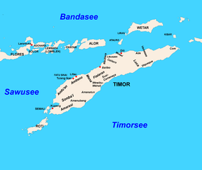
English: Timor in 17th and 18th century
Deutsch: Timor im 17. und 18. Jahrhundert |
| Date | (UTC) |
| Source | |
| Author |
|
| This is a retouched picture, which means that it has been digitally altered from its original version. Modifications: names and towns added. The original can be viewed here: Timor base map plan color.png:
|
I, the copyright holder of this work, hereby publish it under the following licenses:
This file is licensed under the Creative Commons Attribution-Share Alike 3.0 Unported license.
- You are free:
- to share – to copy, distribute and transmit the work
- to remix – to adapt the work
- Under the following conditions:
- attribution – You must give appropriate credit, provide a link to the license, and indicate if changes were made. You may do so in any reasonable manner, but not in any way that suggests the licensor endorses you or your use.
- share alike – If you remix, transform, or build upon the material, you must distribute your contributions under the same or compatible license as the original.

|
Permission is granted to copy, distribute and/or modify this document under the terms of the GNU Free Documentation License, Version 1.2 or any later version published by the Free Software Foundation; with no Invariant Sections, no Front-Cover Texts, and no Back-Cover Texts. A copy of the license is included in the section entitled GNU Free Documentation License. |
You may select the license of your choice.
Original upload log[edit]
This image is a derivative work of the following images:
- File:Timor_base_map_plan_color.png licensed with Cc-by-sa-3.0, GFDL
- 2010-12-15T21:00:42Z J. Patrick Fischer 2000x1683 (123636 Bytes) better
- 2010-12-12T19:35:44Z J. Patrick Fischer 2000x1683 (45083 Bytes) {{Information |Description={{en|1= Map of Timor. * Projection: Equirectangular projection, strechted by 101.0%. * Geographic limits of the map: :* N: -7.0° N :* S: -12.0° N :* W: 122.0° E :* E: 128.0° E * GMT projection:
Uploaded with derivativeFX
File history
Click on a date/time to view the file as it appeared at that time.
| Date/Time | Thumbnail | Dimensions | User | Comment | |
|---|---|---|---|---|---|
| current | 21:11, 19 December 2010 | | 2,000 × 1,683 (299 KB) | J. Patrick Fischer (talk | contribs) | {{Information |Description={{en|1=Timor in 17th and 18th century}} {{de|1=Timor im 17. und 18. Jahrhundert}} |Source=*File:Timor_base_map_plan_color.png |Date=2010-12-19 21:08 (UTC) |Author=*File:Timor_base_map_plan_color.png: *[[:File:Timor_b |
You cannot overwrite this file.
File usage on Commons
There are no pages that use this file.
File usage on other wikis
The following other wikis use this file:
- Usage on de.wikipedia.org
- Geschichte Osttimors
- Liurai
- Wehale
- Com (Lautém)
- Luca (Viqueque)
- Mena (Biboki Moenleu)
- Sonba’i
- Amfo'an
- Wikipedia:Kartenwerkstatt/Archiv/2010-12
- Amanuban
- Amarasi
- Vertrag von Paravicini
- Johannes Andreas Paravicini
- Benutzer:J. Patrick Fischer/Karten, die ich gezeichnet oder überarbeitet habe
- Reich von Luca
- Malaka (Reich)
- Usage on es.wikipedia.org
- Usage on id.wikipedia.org
- Usage on ko.wikipedia.org
- Usage on pt.wikipedia.org