File:Timor-Leste Geological map of zone C.png

Original file (2,924 × 2,068 pixels, file size: 1.95 MB, MIME type: image/png)
Captions
Captions
Summary
[edit]
| Description |
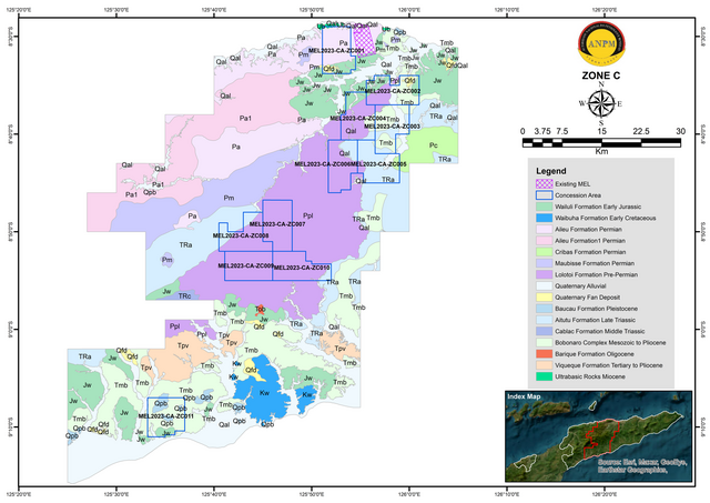
English: Zone C is the largest zone for metallic and minerals other than construction minerals Mining Activities covering few municipalities, such as Manatuto, Aileu, Ainaro, and Manufahi Municipalities, as well as part of Dili Municipality in the Metinaro area and Ermera Municipality in the Letefoho area with a total estimate area of 3,716 km2. This zone mostly contained high magnetic anomalies corresponding with the Aileu Formation, Lolotoi Complex, and Maubisse Formation (Audley-Charles 1968; KARVAK 2022). The indicated mineral potentials within Zone C from previous studies were chromite, manganese, gold, and copper for metallic minerals (AMC 1937; UN-ESCAP 2003) and bentonite, limestone, marble, and some clay mineral resources for non-metallic minerals (UN-ESCAP 2003).
The occurrence of chromite, the chromium ore, within Timor-Leste has been confirmed to be present at Manatuto Municipality hosted within the Aileu Formation, particularly within the peridotite (ranging from lherzolite, harzburgite, and dunite) and their serpentinite equivalent at varying degrees of serpentinization (Lay et al. 2017). The chromite is associated with minute traces of platinum-group elements (PGEs). Additionally, traces of copper and nickel mineralisation was also identified in the area to be associated with this chromite (Lay et al. 2017). Apart from the Illimanu area, Turiscai area of Manufahi Municipality was also identified as one of the area in which there is an indication of precious and base metals based on the previous studies (AMC 1937; UN-ESCAP 2003). The gold reported to occur within quartz vein or as gold nuggets found to be associated with gravel in sections of the Sue, South Laclo and Cler Rivers, suggesting a placer gold deposit occurring within the Manufahi Municipality (AMC 1937; UN-ESCAP 2003). Aside from gold mineralisation mentioned, disseminated copper- gold and copper mineralisation also found in ophiolite sequence similar to copper mineralisation in other part of the country, particularly those identify in Baucau and Viqueque Municipalities (UN-ESCAP 2003). This zone is also noted for its kaolin deposit and identified as the largest indicated resource for kaolin within the country, within the municipality of Aileu (UN-ESCAP 2003; IPG 2017). Other non-metallic mineral such as phosphate also occur within Zone C, particularly within the Manatuto Municipality hosted by the Bobonaro Scaly Clay. Currently there are two existing concession areas located in Manatuto Municipality within Zone C. |
| Date | |
| Source | Autoridade Nacional dos Minerais |
| Author | Autoridade Nacional do Petróleo e Minerais |
Licensing
[edit]
This file is in the public domain in East Timor, because it is published and distributed by the Government of Democratic Republic of Timor-Leste, according to Article 13 of the Indonesia Copyright Law No 6, 1982, which was still valid in East Timor from independence on 20 May 2002 until 27 May 2023.[1]
There shall be no infringement of Copyright for:
|
 |
 |
Per U.S. Circ. 38a, the following countries are not participants in the Berne Convention or Universal Copyright Convention and there is no presidential proclamation restoring U.S. copyright protection to works of these countries on the basis of reciprocal treatment of the works of U.S. nationals or domiciliaries:
As such, works published by citizens of these countries in these countries are usually not subject to copyright protection outside of these countries. Hence, such works may be in the public domain in most other countries worldwide. However:
East Timor has enacted the Code of Copyright and Related Rights in November 2022, it came into force on 28 May 2023. Note: As per Commons policy, this tag alone is not sufficient. You also need to supply a tag that describes why the work is public domain in its country of origin. |
File history
Click on a date/time to view the file as it appeared at that time.
| Date/Time | Thumbnail | Dimensions | User | Comment | |
|---|---|---|---|---|---|
| current | 22:54, 2 January 2024 | | 2,924 × 2,068 (1.95 MB) | J. Patrick Fischer (talk | contribs) | Uploaded a work by Autoridade Nacional do Petróleo e Minerais from [https://mineralstender.anpm.tl/?page_id=66 Autoridade Nacional dos Minerais] with UploadWizard |
You cannot overwrite this file.
File usage on Commons
There are no pages that use this file.
File usage on other wikis
The following other wikis use this file:
- Usage on de.wikipedia.org