File:Thomas Ridout map of Grand River Indian Lands, 1821.jpg

Original file (4,000 × 5,498 pixels, file size: 3.27 MB, MIME type: image/jpeg)
Captions
Captions
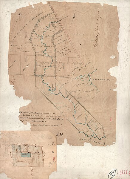
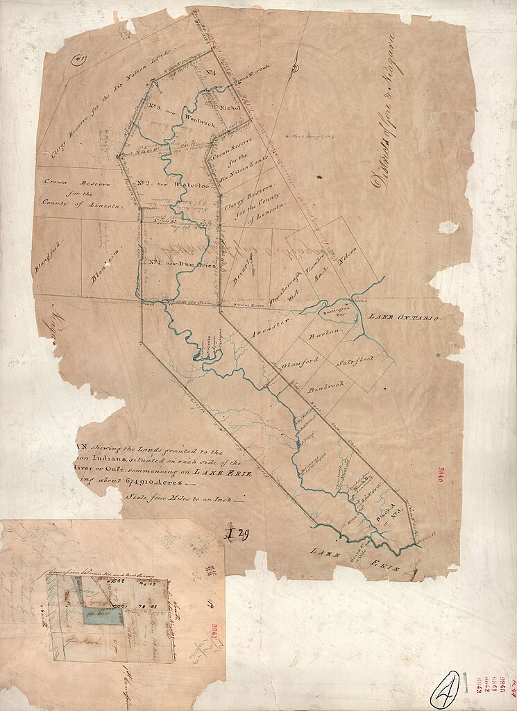
This is a survey of the Six Nation Indian lands completed in 1821. It is sometimes called the Ridout Survey because Thomas Ridout was the Surveyor General of Upper Canada at the time.
The image depicts the lands granted to the Six Nation Indians along the Grand River in Upper Canada. The Haldimand Proclamation of 1784 granted the land. The original survey was undertaken in 1791 to define the area, but records of it were lost.
See en:Haldimand Proclamation for historical information. Also, Charles M. Johnson, The Valley Of The Six Nations: A Collection of Documents on the Indian Lands of the Grand River, 1964, University of Toronto Press, has a great deal of information on the subject. A version is available online at the University of Toronto Library here.
Summary[edit]
| Description |
English: This is a scan of a 1821 survey from Public Archives of Canada |
| Date | |
| Source | Public Archives of Canada |
| Author | Creator:Thomas Ridout |
Licensing[edit]
|
This work is in the public domain in its country of origin and other countries and areas where the copyright term is the author's life plus 70 years or fewer.
| |
| This file has been identified as being free of known restrictions under copyright law, including all related and neighboring rights. | |
File history
Click on a date/time to view the file as it appeared at that time.
| Date/Time | Thumbnail | Dimensions | User | Comment | |
|---|---|---|---|---|---|
| current | 15:29, 20 August 2009 | | 4,000 × 5,498 (3.27 MB) | NormanEinstein (talk | contribs) | {{Information |Description={{en|1=This is a survey of the Six Nation Indian lands completed in 1821. It is sometimes called the '''Rideout Survey''' because Thomas Ridout was the Surveyor General of Upper Canada at the time. The image depicts the lands g |
| 02:10, 13 September 2009 |  | 4,000 × 5,498 (3.27 MB) | BetacommandBot (talk | contribs) | move approved by: User:Common Good This image was moved from File:Thomas Rideout map of Grand River Indian Lands, 1821.jpg This is a survey of the Six Nation Indian lands completed in 1821. It is sometimes called the '''Ridout Survey''' becaus |
You cannot overwrite this file.
File usage on Commons
The following page uses this file:
- File:Thomas Rideout map of Grand River Indian Lands, 1821.jpg (file redirect)
File usage on other wikis
The following other wikis use this file: