File:The road to the Lighthouse, Mull of Kintyre - geograph.org.uk - 484739.jpg
Jump to navigation
Jump to search
No higher resolution available.
The_road_to_the_Lighthouse,_Mull_of_Kintyre_-_geograph.org.uk_-_484739.jpg (640 × 480 pixels, file size: 70 KB, MIME type: image/jpeg)
Captions
Captions
Add a one-line explanation of what this file represents
Summary[edit]
| Description |
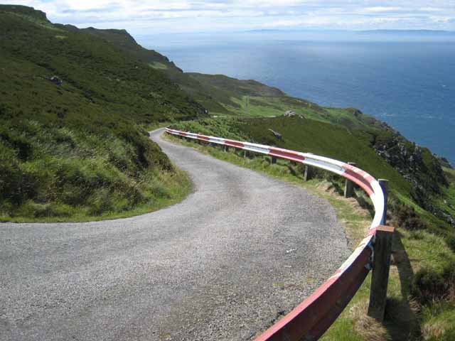
English: The road to the Lighthouse, Mull of Kintyre A tortuous public road leads up to the Gap. Beyond there, an even steeper and more tortuous private road leads down the precipitous hillside to the lighthouse at the Mull of Kintyre. Rathlin Island (Northern Ireland) can be clearly seen on the horizon. |
| Date | |
| Source | From geograph.org.uk |
| Author | Oliver Dixon |
| Attribution (required by the license) | Oliver Dixon / The road to the Lighthouse, Mull of Kintyre / |
| Camera location | | View this and other nearby images on: OpenStreetMap |
|---|
_heading:202.00&language=en)
| Object location | | View this and other nearby images on: OpenStreetMap |
|---|
_heading:202.00&language=en)
Licensing[edit]

|
This image was taken from the Geograph project collection. See this photograph's page on the Geograph website for the photographer's contact details. The copyright on this image is owned by Oliver Dixon and is licensed for reuse under the Creative Commons Attribution-ShareAlike 2.0 license.
|
This file is licensed under the Creative Commons Attribution-Share Alike 2.0 Generic license.
Attribution: Oliver Dixon
- You are free:
- to share – to copy, distribute and transmit the work
- to remix – to adapt the work
- Under the following conditions:
- attribution – You must give appropriate credit, provide a link to the license, and indicate if changes were made. You may do so in any reasonable manner, but not in any way that suggests the licensor endorses you or your use.
- share alike – If you remix, transform, or build upon the material, you must distribute your contributions under the same or compatible license as the original.
File history
Click on a date/time to view the file as it appeared at that time.
| Date/Time | Thumbnail | Dimensions | User | Comment | |
|---|---|---|---|---|---|
| current | 03:01, 5 February 2011 | | 640 × 480 (70 KB) | GeographBot (talk | contribs) | == {{int:filedesc}} == {{Information |description={{en|1=The road to the Lighthouse, Mull of Kintyre A tortuous public road leads up to the Gap. Beyond there, an even steeper and more tortuous private road leads down the precipitous hillside to the lighth |
You cannot overwrite this file.
File usage on Commons
There are no pages that use this file.
File usage on other wikis
The following other wikis use this file:
- Usage on fr.wikipedia.org
- Usage on no.wikipedia.org