File:The Search for Malaysia Airlines Flight 370 - Initial search areas (Southeast Asia) de.svg
Jump to navigation
Jump to search

Size of this PNG preview of this SVG file: 800 × 500 pixels. Other resolutions: 320 × 200 pixels | 640 × 400 pixels | 1,024 × 640 pixels | 1,280 × 800 pixels | 2,560 × 1,600 pixels | 2,000 × 1,250 pixels.
Original file (SVG file, nominally 2,000 × 1,250 pixels, file size: 148 KB)
Captions
Captions
Add a one-line explanation of what this file represents
Typing error. "Lotzte" = wrong, it should be "Letzte"
Summary[edit]
| Description |
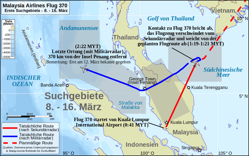
Deutsch: Das anfängliche Suchgebiet für Flug MH370 vom 8. bis 16. März 2014. – Deutsche Version.
English: The initial search area for Malaysia Flight 370 in Southeast Asia (8–16 March) – German version.
中文(简体):马航370航班在东南亚的最初的搜索区域(3月8日至16日)(德文版) |
| Date | |
| Source |
This file was derived from: MH370 initial search Southeast Asia.svg Deutsch: *Flugroute: MH370 – Definition der Unterwasser-Suchgebiete (Australian Transport Safety Bureau)
English: *Flight path: MH370 – Definition of Underwater Search Areas (ATSB)
中文(简体):*飞行路线: MH370 – 水下搜索区域的界定(英文) (澳洲交通安全局)
|
| Author |
|
| Permission (Reusing this file) |
This file is licensed under the Creative Commons Attribution-Share Alike 3.0 Unported license. Attribution: Uwe Dedering
|
| Other versions |
|
| SVG development |

_zh.svg)

_de.svg&action=edit§ion=1)
File history
Click on a date/time to view the file as it appeared at that time.
| Date/Time | Thumbnail | Dimensions | User | Comment | |
|---|---|---|---|---|---|
| current | 00:29, 5 June 2016 | | 2,000 × 1,250 (148 KB) | Shattered Gnome (talk | contribs) | Fixed Wiki-rasterization issue. Fixed some typos and errors from original file. |
| 06:20, 4 June 2016 |  | 1,260 × 788 (1.46 MB) | Shattered Gnome (talk | contribs) | Poor Automatic rasterization of new uploads; will try again another day | |
| 05:12, 4 June 2016 |  | 1,265 × 793 (217 KB) | Shattered Gnome (talk | contribs) | Correct file this time | |
| 05:08, 4 June 2016 |  | 2,529 × 1,586 (200 KB) | Shattered Gnome (talk | contribs) | Vectorized topography; retyped text in place of letter-shaped paths (for file size); adjusted for map conventions | |
| 07:26, 14 August 2015 |  | 1,260 × 788 (1.46 MB) | Furfur (talk | contribs) | trying to optimize the file size ... | |
| 23:10, 14 December 2014 |  | 1,260 × 788 (2.66 MB) | Furfur (talk | contribs) | Höhe -> Tiefe | |
| 22:34, 6 December 2014 |  | 1,260 × 788 (1.36 MB) | Furfur (talk | contribs) | {{Information |Description={{de|1=Das anfängliche Suchgebiet für Flug MH370 vom 8. bis 13. März 2014.}}{{en|1=The initial search area for Malaysia Flight 370 in Southeast Asia (8-16 March) - German version.}} |Source={{Derived from|MH370 initial sea... |
You cannot overwrite this file.
File usage on Commons
The following 6 pages use this file:
- Malaysia Airlines Flight 370
- Commons:WikiProject Aviation/recent uploads/2014 December 6
- Commons:WikiProject Aviation/recent uploads/2015 August 14
- Commons:WikiProject Aviation/recent uploads/2016 June 5
- File:MH370 initial search Southeast Asia.svg
- File:The Search for Malaysia Airlines Flight 370 - Initial search areas (Southeast Asia) zh.svg
File usage on other wikis
The following other wikis use this file:
- Usage on de.wikipedia.org
_de.svg&oldid=684009059)