File:The New Guinea Area - Allied Advance (AMH-43).jpg
Jump to navigation
Jump to search

Size of this preview: 800 × 327 pixels. Other resolutions: 320 × 131 pixels | 640 × 262 pixels | 1,200 × 491 pixels.
Original file (1,200 × 491 pixels, file size: 96 KB, MIME type: image/jpeg)
Captions
Captions
Add a one-line explanation of what this file represents

|
This historical map image could be re-created using vector graphics as an SVG file. This has several advantages; see Commons:Media for cleanup for more information. If an SVG form of this image is available, please upload it and afterwards replace this template with
{{vector version available|new image name}}.
It is recommended to name the SVG file “The New Guinea Area - Allied Advance (AMH-43).svg”—then the template Vector version available (or Vva) does not need the new image name parameter. |


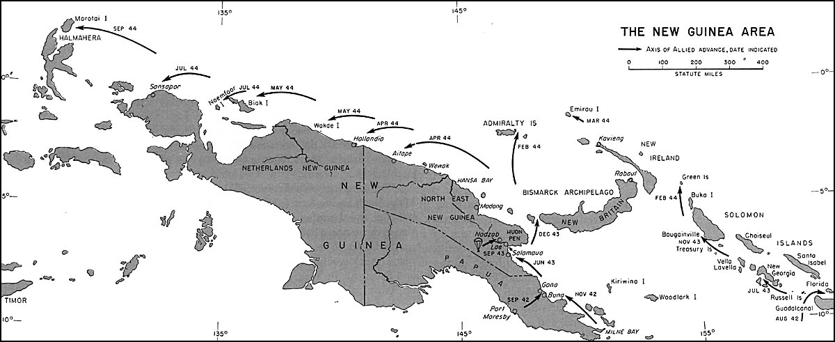
| Description | The New Guinea Area - Axis of Allied Advance with Dates |
| Source | http://www.ibiblio.org/hyperwar/AMH/AMH/maps/AMH-43.jpg |
| Author | US-Army |
| Permission (Reusing this file) |
Public Domain |
The content of this web site is made up, primarily, of "public domain" (non-copyright) materials in English:
ibiblio.org is a collaboration of the Center for the Public Domain and The University of North Carolina - Chapel Hill. For more information about Hyperwar see: Ibiblio.org Hyperwar Copyright-Information on other ibiblio-sites may differ from PD. For more information please see on these special pages. For general information about ibiblio.org see: About ibiblio
|
File history
Click on a date/time to view the file as it appeared at that time.
| Date/Time | Thumbnail | Dimensions | User | Comment | |
|---|---|---|---|---|---|
| current | 12:06, 19 August 2013 | 1,200 × 491 (96 KB) | W.wolny (talk | contribs) | {{Information |Description=The New Guinea Area - Axis of Allied Advance with Dates |Source=http://www.ibiblio.org/hyperwar/AMH/AMH/maps/AMH-43.jpg |Date= |Author=US-Army |Permission=Public Domain |other_versions= }} {{Template:Ibiblio-Hyperwar.org}} |
You cannot overwrite this file.
File usage on Commons
There are no pages that use this file.
File usage on other wikis
The following other wikis use this file:
- Usage on de.wikipedia.org
.jpg&oldid=280204606)